
by John Lawrence Connelly, Davidson County Historian.
For a large part of the twentieth century Nashville residents either ignored or did not know that an area north of Jefferson Street was once a prominent neighborhood where many of Nashville’s leading citizens lived. To a large extent, it was a German community that began flourishing heartily in the 1840s by blending its German heritage with Irish, Italian, Swiss, and Jewish neighbors, in public schools and sometimes in churches. The Catholic Church of the Assumption, founded in 1859, held many of its services in German, as did the German Methodist Church (Barth Memorial), founded in 1854 on North College Street (today’s Second Avenue North). Many prosperous merchants of the city lived in Germantown, and their names hung prominently on retail store signs downtown: Rust, Zugermann, Zickler, Ratterman, Buddeke, Thuss, Grossholz, Jensen, Jeck, and Wheling, to name a few. What’s more, the German names in the community reflected a strong Lutheran heritage.
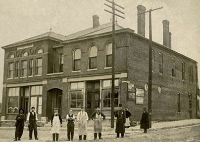
Within the German community many immigrants worked as butchers, a practice brought over by immigrants from Europe. These tradesmen often killed livestock and cut up the meat in their back yards or in nearby lots. Once they were able to sell their products to the Nashville Market House and other businesses, the number of people who peddled meat from door to door declined rapidly. Many residents opened their own shops or stalls. Names such as Jacobs, Dieterle, Stier, Warner, Oliver, Neuhoff, Power, Petre, Laitenberger, and White were among the best-known butchers from North Nashville. Meat suppliers from Butchertown developed the Christmas spice round, a Nashville holiday meat that would become a celebrated local tradition.
By 1915 the changes that would eventually destroy the neighborhood were beginning to take place. Just as the people who live in a community do not stay the same, old neighborhoods also undergo change. Shortly after the turn of the century, as streetcar lines expanded and motor transportation began to make advancements, Nashville saw a definite trend among the residents to move away from the “walk-to-town” areas. Moreover, the development of refrigeration led to the phasing out of many small butchering businesses. Large packing houses began to infringe upon the pleasant residential atmosphere of the neighborhood, which had often been advertised in local newspapers as a growing and fashionable community. It was World War I, however, that dealt the final blow to Germantown.
Wilbur F. Creighton’s book, Building of Nashville, provides an explanation: “In 1917 the reservoir was closed to visitors. The paper had been filled with stories of German atrocities, such as the use of poisonous gases and deliberate infection of water supplies.” Other cases of exaggerated emotional response to the war included suggestions by some that citizens should “kill their dachshunds.” Fearing for their safety, many German families instructed their older members to stop speaking German, even at home.
Changes within the Barth Memorial Church provide a good example of what was happening in Germantown. For many years sermons were delivered in German, but after World War I began, it was resolved that the church should offer only English services. Catholics and Lutherans with German backgrounds did likewise. The uniqueness of a small community with ties to the “Fatherland” was over. The neighborhood as it once was would never come back, and its steady decline continued until a handful of urban pioneers decided to attempt to create a new Germantown in the 1970s.
Germantown experienced a great deal of decay over the years as many houses were torn down and others extensively altered. Nonetheless, studies made by the Metropolitan Historical Commission in the 1970s stated: “A large percentage of structures are still intact, and it can become a viable neighborhood. The quality of architecture is exceptional, and the condition of the structures is, for the most part, quite sound.”
Today Nashville’s Germantown Historic District is one of the most architecturally heterogeneous neighborhoods in the city. The eight-block area contains a wide variety of styles and types of residences built between the 1840s and 1920s. Because of its historical and architectural significance Germantown was listed in the National Register of Historic Places in August, 1979.
For the past several years new residents have worked individually and collectively to restore Germantown. The Germantown Association has become a dynamic neighborhood group where old and new residents come together to plan for the future. A ride through the area today reveals a lively community with new and restored houses, beautiful flowers and trees, a new supermarket, a new pharmacy, and attractive brick sidewalks. Once again Nashville can take pride in this lovely neighborhood located within a few steps of the Bicentennial Mall, featuring a magnificent view of the State Capitol. Germantown has come back, with almost unlimited potential for tomorrow.
In 1980 members of the Catholic Church of the Assumption and the Monroe Street United Church (two historic churches that survived the lean years) came together to give Nashville its first Oktoberfest. This event, held on the second Saturday in October, has become one of Middle Tennessee’s most popular celebrations. The Germantown Association has sponsored a Maifest celebration for the past decade and often sells out all of its tickets. Yes, Germantown is on the map again! (2001)
Note: Although the Covid-19 pandemic has forced the cancellation of Oktoberfest for a couple of years, residents plan to bring it back soon.

