Perilous Times in Nashville

Musings by Mike Slate.

Just as in our national history, the question of personal safety has arisen many times in Nashville. For at least fifteen years after our 1780 founding, not a man, woman, or child was safe. Indians devised surprise attacks again and again on the encroaching settlers, and many lives were lost – some, like Jonathan Jennings, through horrific means.

Never has there been a Nashville panic like that of February 1862. After Fort Donelson fell on February 16, it became clear that Union troops would occupy Nashville. Many Nashville secessionists quickly scattered to the winds, while others, determined to remain, hunkered down in fearful anticipation of the arrival of the invading army.

Soon afterwards, as if the Civil War had not brought enough agony, one of several vicious cholera epidemics claimed as many as 800 Nashville lives in the summer of 1866. Seven years later, in 1873, nearly 750 Nashvillians perished in another outbreak of the terrible disease.

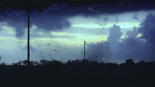
By the end of the day on March 22, 1916, about thirty-two square blocks of East Nashville had become a wasteland. A particularly voracious fire, driven by high winds, had devoured nearly 700 buildings and homes. Not many years later, on March 14, 1933, another unwelcome guest—a savage tornado—roared through East Nashville threatening again the very foundations of the community.

Remains of a fire engine from Company #4 near Russell and Fatherland Streets after the 1916 Edgefield fire (TSLA photo)

During the 1960s Nashville was a highly visible stage for the Civil Rights Movement. At times it looked as though our city might self-destruct out of racial tension. Neither whites nor blacks felt safe as the pressures created by mandated integration resulted in legal battles, demonstrations, sit-ins, and riots.

Nashville was left largely to its own devices during the destructive flood of May 2010, when it received more than 13 inches of rain in two days. The fast-rising water displaced 10,000 residents, produced $2.3 billion in property damage, and caused a number of deaths. Receiving little help from outside, neighbors helped neighbors, and volunteers turned out by the hundreds to help with clean-up efforts.

Nashville flood 2010

Late on March 2, 2020, a category-EF3 tornado roared through Nashville and into Mt. Juliet along nearly the same path as the 1933 storm, causing five deaths, over 200 serious injuries, and $1.5 billion in property damage, including a disproportionate number of churches and school buildings. The Covid-19 pandemic had just begun to affect the health of the community as tornado clean-up got underway, and the remainder of the year was consumed by efforts to sustain schools, businesses, and healthcare facilities during a time of unprecedented illness and hardship. And then, just as new vaccines brought hope, the Christmas morning bomb blast on 2nd Avenue downtown shattered our peace once again.

Second Avenue, Nashville, after Christmas bombing 2020

Yet somehow, through these and other perilous times, Nashville has survived, and even thrived. We have always been an industrious lot, constructing landmark public buildings, universities, churches, libraries, businesses, and homes. More important, we have strengthened our collective character and have raised our children to become leaders in business, education, law, politics, medicine, and music. We have produced artists and poets, authors and publishers, factory technicians and practical nurses. We, along with our nation, have become a diversified and enriched society that must continue to mature. We have proudly earned our motto, “Nashville Strong!”

Battle of Nashville Monument: the 1997-1999 Restoration

Notes and comments from the Nashville Historical Newsletter.

  1. Jim Summerville, “The Battle of Nashville Monument,” NHN, March 1997

The pace is quickening at Hawkins Partners, chief contractor overseeing the relocation and restoration of the Battle of Nashville Monument. A concept plan for the new site, the southwest corner of Granny White and Battlefield Drive, is underway. By early April the firm hopes to turn over to the state architect the bid packages for all subcontracting, including the sculpting of the new 40-foot obelisk and angel that were part of the original monument. Groundbreaking may take place sometime this summer.

The restored monument in its new location (NHN photo)

The Tennessee Historical Commission, which owns the monument, selected the new site in 1992. Thanks to federal, state, and local funds, as well as numerous private contributions, this great art and history treasure will be brought back to public view and appreciation.

The driving force behind the monument’s creation was May Winston Caldwell and the Ladies’ Battlefield Association. In 1911 the group secured four acres at Franklin Road and Thompson Lane, where in 1863 Union and Confederate forces had clashed fiercely. At this place the association determined to erect a memorial to mark the last major action in the western theater, the Battle of Nashville.

World War I delayed the project, and by the time the Association commissioned sculptor Giuseppe Moretti, the idea for a solders’ memorial had taken on new significance. On the battlefields of Europe, Southern and Northern young men had fought side by side, reuniting the country under one flag. Moretti expressed this idea in two rearing horses, representing the former enemies, yoked together by a youth who stood for the young men who had served on foreign fields.

The original monument at Franklin Road & Thompson Lane (postcard from NHN collection)

Finally dedicated in 1927, the Battle of Nashville monument stood proudly for many years. Then in 1974 a tornado destroyed the obelisk and the Angel of Peace that crowned it. In the 1980s a 13-acre interchange for I-440 and I-65 pressed against the site, isolating the remaining bronze, the youth and horses, on a pinched plot of ground. For some time, acid rain has been pitting the soft marble of the base. Lately, vandals have scrawled graffiti on the stone.

This great wrong will now be righted, as the Battle of Nashville comes to its new home. In the vicinity of the new location, the Confederate line under General A. P. Stewart reached its farthest advance on the afternoon of December 15, 1864.

2. NHN: A Work of Art Needs Your Help, September 1997

Contractors working on the restoration of the Battle of Nashville Monument would be grateful to hear from anyone who possesses any fragments of the original sculpture. Pieces of the obelisk and angel would enable the careful replication of the work, which was hurled to the ground and smashed during a 1974 tornado. All fragments loaned for this purpose will be handled with care and returned promptly to the lender. Contact: The Association for Tennessee History.

3. NHN: History in Action, March 1998

Approximately $300,000 will be needed to complete the interpretive park that will be the new site for the refurbished Battle of Nashville Peace Monument. The park, located at Granny White Pike and Battlefield Drive, is scheduled to open this summer. Preliminary site preparation has begun, and sculptor Colley Coleman has been producing shop drawings that will determine the proper cutting of the new granite for the Monument. The Tennessee Historical Commission is welcoming donations to the park project.

4. NHN: History in Action, May-June 1999

Giuseppe Moretti’s Battle of Nashville Peace Monument is scheduled to be rededicated on Saturday, June 26, at 10:00 a.m. at the new historical park on Battlefield Drive. The monument, a tribute to those who fought and died in both the Civil War and World War I, was damaged by a 1974 tornado and neglected for years thereafter. The renewed monument is also a tribute to those organizations and individuals who refused to allow it to lie in ruin.

The park receives many visitors.

5. NHN: News & Notes, July-August 1999

The restored Battle of Nashville Peace Monument, thought to be the only Civil War monument in the United States to honor both Union and Confederate soldiers, was rededicated on June 26, 1999. The principal speaker for the occasion was venerable Nashvillian Wilbur Foster Creighton Jr., a hearty ninety-two years of age. Ward DeWitt Jr., chairman of the Tennessee Historical Commission, appropriately dedicated the Peace Monument to our city’s youth. The now-pristine monument – with its mighty granite base, its bronze sculpture, and its triangular obelisk – rises to thirty feet and is topped with an Angel of Peace. Fittingly located in a new park at Granny White Pike and Battlefield Drive, this memorial could become, we believe, one of the most frequently photographed of all Tennessee outdoor statuary.

At the Stone-Stoner Confluence

Musings by Mike Slate.

About half a mile south of the Stone’s River bridge on Lebanon Road, along the new greenway trail, you can peer across the river at the place where Stoner’s Creek empties into Stone’s River. If you know your history, you will stop dead in your tracks for a few moments, knowing that you have arrived at a historic location. The confluences of streams were landmarks for the pioneers and early historians . . . and no doubt for the Indians before them. Whereas we might say today that Central Pike is just past the Stone’s River bridge, the pioneers would more likely have said that a trail was just past the point where Stoner’s Creek flows into the Stone’s River.

Painting by Fred Hetzel (from NHN collection)

Standing on that special spot and watching the Stoner rushing into the Stone awakens the realization that stream confluences are also confluences of lives: hundreds, maybe thousands, of folks have stood in this same area long before the greenway made it accessible to us greenhorn pathfinders. Uriah Stone, for whom Stone’s River was named, probably stood there. Michael Stoner, after whom Stoner’s Creek was named, surely scouted around that spot. I wish I could tell you that these two “long hunters,” so called because they explored and hunted for extended periods of time, met each other at that place and marveled together about the similarity of their surnames. That discussion may well have taken place, but probably not there. Both Stone and Stoner might have hunted in the Wellen party in the early 1760s, but that group did not follow the Cumberland as far west as its confluence with Stone’s River. It appears that the two pioneers explored our area at separate times in the late 1760s, about a dozen years before Nashville (or “Nashborough,” as it was first called) was founded.

Nashville co-founder John Donelson would probably also have stood on that spot. He planted corn in the adjoining bottom land, called “Clover Bottom,” and the Donelson family eventually lived nearby. No less an international dignitary than Andrew Jackson may very well have strolled that area himself, perhaps while his horses were warming up on the Clover Bottom race track. Another intriguing possibility is that Daniel Boone might have stood there. Boone and Stoner were not only compatriots but also close friends. Though I know of no record of a Boone visit to the Stone’s River, he could have come with Stoner at some point in time.

Photo by Paul Pierce

Nineteenth-century historians mention the existence of a Stoner’s Lick, located at some unspecified point on the creek. This would have been a salt lick, an area where salt or a salt rock outcrop rose to the surface. Such places were not just landmarks; they, like the French Lick around which Nashville was founded, were quite valuable in other ways. Buffalo and other game congregated at the licks, assuring easy access to meat and fur for the Indians, explorers, and settlers. Stoner’s Creek winds much farther east than it appears to on some maps [Stoner Creek Elementary School in Mt. Juliet, destroyed by the March 2020 tornado, is currently being rebuilt (2021)], so the lick could have been anywhere along several winding miles. For example, since buffalo trails often became roads for the settlers, the lick could have been approximately at the intersection of today’s Central Pike and Stoner’s Creek. Perhaps the driveway to the emissions inspection station is astride the lick! At least we still have the confluence, since the lick is probably lost forever.

I will conclude these musings with a linguistic grumble: Stone’s River and Stoner’s Creek do not exist on modern maps. Oh, the streams are there, all right, but the names have changed. Although most nineteenth-century historians wrote both names in the possessive form, somewhere along the way the apostrophes dropped off. Considered acceptable now are “Stones River” and “Stoners Creek,” despite the fact that the long hunters’ names were Stone and Stoner. I will hazard a guess that the corruption occurred first on maps, for lack of space or accuracy, and then continued on into texts. However it happened, if you drive out Lebanon Road and cross the Stone’s River bridge today, you will see a sign that reads “Stones River.” Feel free to smile at that sign, realizing that you know better.


Note: In 2011 a reader informed us that his ancestor Thomas Wilson bought this land from James Rucker in 1805. Wilson died in 1811, but his sons lived there until the 1830s and then migrated to Memphis. One of his daughters married William Creel, and another married Timothy Dodson.

The Old Nashville Market House, 1828-1937

by Dave Price.

Our original market house was completed during 1802 and can be seen in the well-known map of 1804 Nashville, which appeared in Clayton’s History of Davidson County, Tennessee. Its replacement was begun in April 1828 and was occupied in January 1829. This structure, shown on the 1831 J.P. Ayres (Doolittle & Munson) map, consisted of a long market shed running north and south with a two-story building at each end.

Photograph of the Public Square courtesy of Debie Oeser Cox, https://nashvillehistory.blogspot.com/

The Ayres map was surrounded by a number of drawings of local buildings and scenes, so we know what the southerly building looked like. It was the “Tennessee Lottery Office,” the image of which has been reproduced, although I am unable to cite such a copy in one of the standard histories. Interesting features of this Lottery Office are a recessed arch shape in the brick on the west side of the building and round windows in the upper corners of the south end.

A “salt print” (dated ca. 1856) of the west side of Nashville’s Public Square attracted a good deal of attention a few years ago when the State Museum purchased the rare item at a Sotheby’s auction. (We old Nashville buffs had been aware of a copy negative in the state archives for years.) The print reveals the same features mentioned above in the northwest corner of the northerly building, indicating that the matching original end buildings of the market house were still in place with some modifications: single story wings added to the south (and we presume north) sides of the end buildings and a cupola added to the roof of the south building (and probably to the north one as well, although it cannot be seen in the print).

A familiar photo taken from Capitol Hill a few years later shows that the end buildings had either been extensively remodeled or replaced with much larger three-story structures having two square towers on each end building. This image is reproduced in Adams-Christian, p. 53. Since the old Methodist Publishing House is shown, the picture must date from before 1873. The southerly building at some point became the City Hall, and Creighton tells us that the Supreme Court met in one of the buildings for a time and that 100 stalls existed in the market section or long connecting shed.

A good view of the southerly building can be seen in James Patrick’s Architecture in Tennessee, 1768-1897, where it is suggested that Adolphus Heiman may have remodeled the buildings “about 1855.” Despite the estimated dates, the “ca. 1856” image was obviously made prior to the “about 1855” remodeling. Incidentally, this building is shown in Max Hochstetler’s great Opryland Hotel mural, which can be seen on the cover of the Summer 1990 Tennessee Historical Quarterly. A view that shows both end buildings and the connecting market building is seen in Jack Norman’s The Nashville I Knew, p. 125.

Although not mentioned by any of the histories that I consulted, the southerly building was consumed by the Burns Block fire on the square during the night of January 2, 1897. The fire company stopped at the site of an old cistern between the Court House and the Market House but found it had been Macadamed over. During the delay in finding a new water source, the old dilapidated City Hall was engulfed in flame and the crowd shouted, “Let it burn!” which is exactly what happened.

This fire was responsible for the replacement of the City Hall with the large 1898 building that older readers will recall (Norman has a good view of this on p. 122 and an unusual architectural drawing is found in the photo section of Fedora Small Frank’s Beginnings on Market Street).

In the meantime the northerly building still had at least one of its towers in an 1892 photo but had lost both towers by 1910. This building contained the office of the Market Master and such city offices as those of the Meat and Dairy Inspectors and was generally called simply, “the north end.” The new City Hall remained much the same, although much of its one large tower was gone by the time of its 1936-37 demolition. The March 14, 1933, East Nashville Tornado caused some damage on the square and this may have been when the tower was shortened.

Aerial photographs taken during the construction of the present (Woolwine) Court House show that, while the market house section and the northerly building were razed along with the Strickland Court House (since they lay in the path of construction), the City Hall was actually a few feet south of the new building and was the last part to fall. It is also obvious from these photos that the market section had been widened considerably over the years; it contained 114 or more stalls by the time of its demise.

The later (1937-1955) Market House stands today behind the present court house and is still in use as the Ben West Building, or more commonly the “Traffic Court Building.” The once-familiar wagons are gone, and the farm trucks that once surrounded the Court House moved north of the Capitol to the new Farmer’s Market in 1955. That market has now been replaced and will no doubt be recalled by a later generation as “the old Farmers’ Market.” (1998)

The 1933 Nashville Tornado

by Kathy B. Lauder.

One hundred years after the first tornado was catalogued in Middle Tennessee,1 Nashville found itself facing the deadliest storm in its recorded history up to that time. Although many residents believed that the hills to the south and west would protect the city from approaching storms,2 weather conditions on March 14, 1933, were creating a recipe for disaster. At 3:00 the temperature had reached 80 degrees – a record high for the date3; meanwhile, a strong cold front was speeding toward Nashville from the northwest, carrying a line of powerful thunderstorms. The front edge of the system hit after sunset, dropping 0.81 inches of rain and large hailstones.4

The tornado followed the storm over the western hills, touching down at Charlotte Pike and 51st Avenue just before 7:30, shattering windows as it passed over the State Capitol, and picking up strength as it approached the Public Square. There it damaged several buildings as it passed within 400 feet of the Weather Office.5  After it crossed the Cumberland River into East Nashville, its path widened to 800 yards. By now an F3* tornado, it tore through the dark into heavily populated neighborhoods, destroying homes, schools, churches, and businesses.6 

Public domain image from spc.noaa.gov

The storm hurtled on into Donelson and Hermitage, demolishing several more homes and a filling station, uprooting huge trees, splintering utility poles, and injuring several residents.7 From there it continued into Wilson County, creating additional casualties and severely damaging 228 buildings, most of them in Lebanon.8 

The tornado, which traveled for 45 miles through three counties, caused 11 deaths in Davidson County, 4 more in Wilson County, and at least 45 injuries requiring medical treatment, before it lifted and dispersed over Smith County.9 During the next few days Nashville’s City Building Office estimated that 1,500 buildings had been damaged by the storm, 800 so seriously as to be uninhabitable.10 Total recorded property damage included 1,400 homes, sixteen churches, thirty-six stores, five factories, four schools, a library, and a lodge hall.11

Nashvillians had no warning. At that time the Weather Bureau prohibited forecasts of approaching tornadoes, believing they would cause widespread panic.12 As a result, many of those killed or injured did not have time to seek shelter.


* According to the Fujita scale of tornado intensity, an F3 tornado (158-206 mph) can cause severe damage: “roofs and some walls torn off well-constructed houses; trains overturned; most trees in forest uprooted; heavy cars lifted off the ground and thrown.” (2015)


SOURCES:

1   Rose, Mark. “A Tornado Climatology of Middle Tennessee (1830-2003).” Nashville: National Weather Service Forecast Office.            http://www.srh.noaa.gov/ohx/?n=tornadoclimatology  (Accessed 1-10-2015)

2   Beard, William E. “Tennessee Calendar.” The Banner, March 14, 1940.

3   Rose, Mark. “The Nashville Tornado of March 14, 1933,” Nashville: National Weather Service Forecast Office. http://www.srh.noaa.gov/ohx/?n=nashvilletornado  (Accessed 1-10-2015)

4   Rose. “The Nashville Tornado.”

5   Rose. “The Nashville Tornado,” Appendix.

6   Beard. 

7   Rose. “The Nashville Tornado.”

8   Rose. “The Nashville Tornado.”

9   Rose. “Tornado Climatology.”

10   “Relief Work Quickened in Storm Area.” The Banner, March 16, 1933.

11   Beard.

12  Williamson, R. M. “Tornadoes So Rare There Is No Need for Constant Fear, Weatherman Says.” The Banner, March 11, 1934.

Slavery at the Hermitage: Fascinating Finds

by Ashley Layhew White.

The Hermitage, Andrew Jackson’s imposing home, survives today as a memorial to American history, to the old days of Tennessee, and to true love. Still standing proud and stately, it has endured poverty, the War Between the States, and the 1998 tornado. Today, perhaps more than ever before, The Hermitage serves to inspire and instruct us.

Recent archeological work at The Hermitage has uncovered some significant details of everyday 19th century slave life. Interesting finds in and near slave cabins on the property include sewing items, toys, and bits of money. The discovery of pencils and slates in every excavated cabin, indicating that Andrew Jackson’s slaves were literate, is surprising and leads us to re-examine some of our ideas about slave life. Good luck charms found at the dig sites are also fascinating, especially the Hand of Fatima which was used to ward away evil spirits. Underground “hidey holes” have also been great sources for archeologists at The Hermitage. Items stolen from the main house or passed along from a slave on a neighboring farm were commonly hid in these secret places.

Though it has become more or less expected to find them on plantation digs, the excavation of gun parts at The Hermitage is nevertheless startling. Hammers, flints, and lead shot have been found, pointing toward gun possession among the slaves. Why would Andrew Jackson allow slaves to bear arms? One plausible explanation is that the slaves used guns to hunt game which included raccoons, squirrels, turtles, and deer. By allowing slaves to hunt, plantation owners could promote self-sufficiency in the slave community.

Archeologists at The Hermitage are optimistic about what the future will teach us about the past, and their successful work reinforces the role of the great plantation as a national treasure. The many fortunate discoveries they have made tempt us to ask: Has the Hand of Fatima had something to do with it?


Ashley Layhew White was a junior at McGavock High School in Donelson, Tennessee, when she wrote this essay for the May-June 2000 newsletter. Since that time she has become a respected historian in her own right.