Buchanan’s Station and Cemetery

by Mike Slate.

Buchanan’s Station was a fortified settlement established about 1784 during the pioneer era of Nashville, Tennessee. Located on a bluff overlooking Mill Creek in today’s Donelson, the homestead was founded by Major John Buchanan who lived there with his family and other settlers until his death in 1832.1 The station is best known as the site of the famous Battle of Buchanan’s Station, which occurred on September 30, 1792.2

In addition to being situated along one of Nashville’s earliest roads, originally called the Lower Trace3 and later described as the road to Buchanan’s Mill,4 the fort was also near the old Nickajack Trail5 as well as what has been called the First Holston Road.6 Eventually the road by Buchanan’s Station became the southern artery to Andrew Jackson’s Hermitage estate and, by about 1869, the approximate route of the old Tennessee & Pacific Railroad.7

Young reenactor at a 2012 Buchanan’s Station Cemetery event. The orange flags near her mark recently identified graves. (NHN photo)

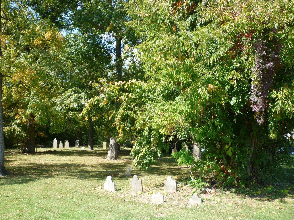
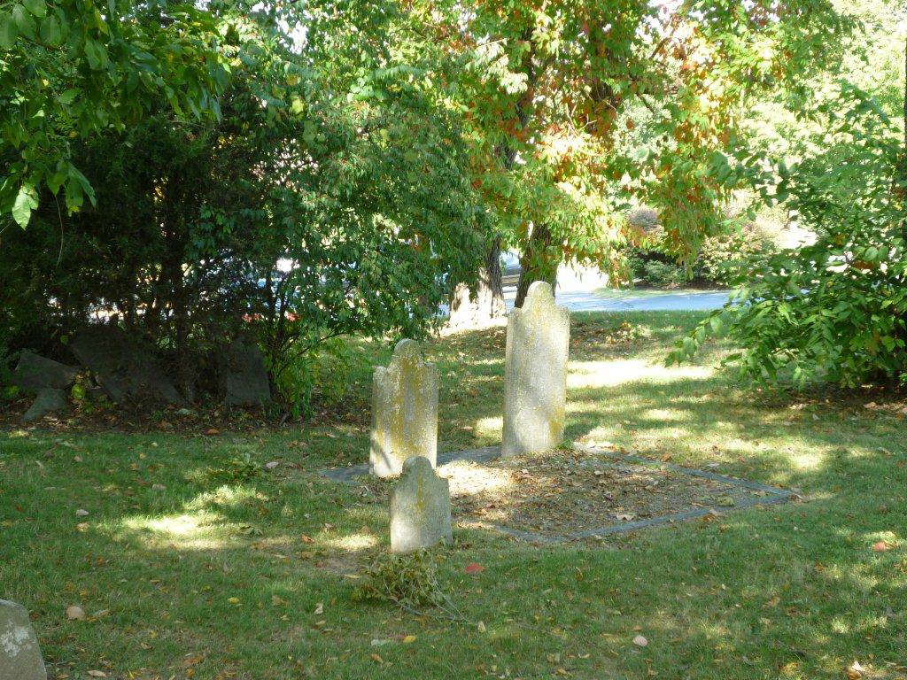
The fort is known to have been positioned precisely at the northwest corner of today’s Elm Hill Pike and Massman Drive, and a state historical plaque marks the spot.8 A large commercial building now covers the site. Not seen from Elm Hill Pike but clearly visible from Massman Drive is the extant Buchanan’s Station Cemetery, the only vestige of the original settlement and one of the oldest pioneer graveyards in Middle Tennessee. Buried here are Major John Buchanan (1759-1832) and his wife Sarah “Sally” Ridley Buchanan (1774-1831), along with about 65 other family members, affiliated settlers, and possibly slaves. Many graves are marked only by anonymous fieldstones.9 Notably, historical circumstances indicate that at least five frontiersmen who were killed by Indians are probably buried in the cemetery: Samuel Buchanan,10 Cornelius Riddle,11 John Buchanan Sr.,12 William Mulherrin,13 and John Blackburn.14

Largely because it was the venue of the remarkable 1792 Indian attack, Buchanan’s Station has been frequently mentioned or discussed by both amateur and professional historians for well over two centuries.15 Buchanan’s Station was, and continues to be, an archetypal intersection of pioneer culture, involving migration dynamics, settlement formation, land acquisition, conflict with Native Americans, and integration into the developing American West.


1 According to author Laurence Trabue, Richard Buchanan (a son of Major John Buchanan) sold the Buchanan’s Station location to Ralph Smith in 1841. Thus, the station remained with the Buchanan family until that year. I use the 1832 date in order to delineate the years that John Buchanan himself lived there. See Laurence O. Trabue, “Early Nashville Homes, 1780-1830,” in Graham, Eleanor, and Mary Glenn Hearne, Nashville Families & Homes: Paragraphs from Nashville History Lecture Series, 1979-81 (Nashville: The Nashville Public Library, 1983), 111.

2 See the “Battle of Buchanan’s Station” article.

3 Buchanan’s Station was situated on North Carolina land grant #83. The survey warrant for that grant located the land “on Mill Creek Where the Lower Trace Leading to Stones River Crosses Sd Creek.” Apparently, today’s Elm Hill Pike, or a portion thereof, was originally known as “the Lower Trace,” indicating an old buffalo trail. The warrant is transcribed in Drake, Masters, & Puryear, Data Supplement 1 for Founding of the Cumberland Settlements: The First Atlas, 1779-1804 (Gallatin TN: Warioto Press, 2009), 136-137.

4 See the “Major John Buchanan” article, note 7.

5 The Nickajack Trail, which was a segment of the old Cisca and St. Augustine Indian Trail, ran from Chickamauga Indian country near today’s Chattanooga northwest to Nashville. The Indians who attacked Buchanan’s Station in 1792 probably approached the station via this trail, or portions thereof. Today’s Murfreesboro Road may follow the original route of the Nickajack. As the trail entered Nashville it came very close to Buchanan’s Station. Regarding the Nickajack and other trails, see William E. Meyer, Indian Trails of the Southeast (Davenport IA: Gustav’s Library, 2009, reprint from the “Forty-second Annual Report of the Bureau of American Ethnology” 1924-25), especially page 848 and the included maps.

6 The term “First Holston Road” is used in Masters & Puryear, Thoroughfare for Freedom: The Second Atlas of the Cumberland Settlements, 1779-1804 (Gallatin TN: Warioto Press, 2011), especially pages 96-97. Created in the spring of 1788, this was the first trail blazed from Nashville across the Cumberland Plateau to Knoxville. It preceded the Cumberland Road (also called Avery’s Trace) that was soon afterwards built on the north side of the Cumberland River. The First Holston Road proceeded from Nashville “via Buchanan’s Station” according to pioneer William Martin’s account in Paul Clements, Chronicles of the Cumberland Settlements (Nashville: self- published, 2012), 288.

7 The southern or lower road to the Hermitage appears on Matthew Rhea’s 1832 map of Tennessee, and the route of the Tennessee & Pacific Railroad appears on Wilbur Foster’s 1871 map of Davidson County, Tennessee.

19th century house on the site of Buchanan’s Station, Elm Hill Pike at Massman Drive. The log building (right) is a remnant of the original 1780 fort. These structures were later demolished and replaced by an industrial park. (1936 photo courtesy of TN State Library & Archives)

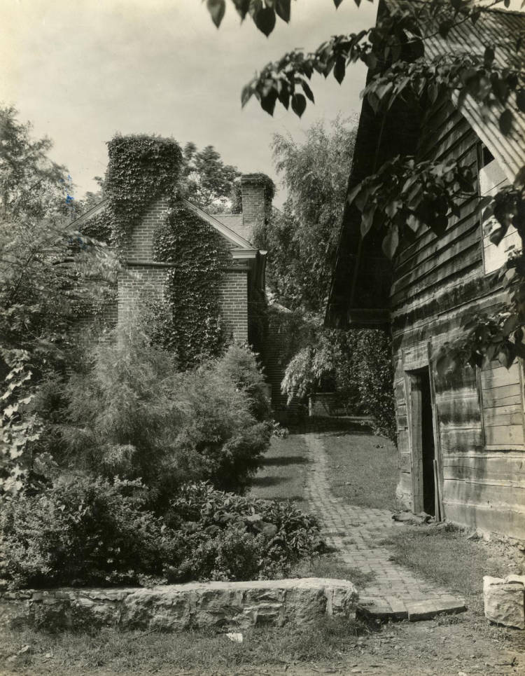
8 Several sources nicely align to present almost incontrovertible proof of the precise location of the Buchanan’s Station main structure. One of the most important is Roberta Brandau, ed., History of Homes and Gardens of Tennessee (Nashville: Parthenon Press, 1964 edition of the 1936 original), 142-144. In the entry therein titled “Buchanan Station,” Ralph Smith’s “Mansion House” is pictured and captioned as “on the site of the original Buchanan structure.” Smith’s mansion became the Knapp Farm Clubhouse (owned by George Peabody College), the exact location of which is known to many contemporary Nashvillians since it was not torn down until shortly after 1980. Brandau aligns with Trabue, 111.

9 See archeologist Dan Allen’s report: Dan S. Allen, “Archaeological Survey of the Buchanan’s Station Cemetery” (Murfreesboro: Dan S. Allen & Associates, 2013), 31.

10 Samuel was the second of Major John Buchanan’s brothers to be killed by Indians (the first was Alexander during the “Battle of the Bluff”). Harriette Simpson Arnow reports that Samuel was killed on May 8, 1786, while out ploughing in the field near the creek, apparently at Buchanan’s Station. See Harriette Simpson Arnow, Flowering of the Cumberland (Lincoln: University of Nebraska Press, 1996, new edition of the 1963 original), 241-242. Samuel may have been the first person to be buried in the Buchanan’s Station Cemetery.

11 Cornelius Riddle was killed in November 1786 near Buchanan’s Station while hunting turkeys. See Clements, 249. Harriette Simpson Arnow speaks of Riddle (she calls him “Ruddle”) as living at Buchanan’s Station with his wife (the former Jane Mulherrin), and Arnow goes so far as to describe the couple’s cabin at the station. See Harriette Simpson Arnow, Seedtime on the Cumberland (Lincoln: University of Nebraska Press, 1995, new edition of the 1960 original), 366.

12 John Buchanan Sr. was hacked to death with a tomahawk, in the presence of his wife (Jane Trindle Buchanan), inside Buchanan’s Station in 1787. See Arnow, Flowering of the Cumberland, 6. The foremost account of this tragedy is in G.W. Featherstonaugh, Excursion through the Slave States, Vol. I (London: John Murray, 1844), 205. John Sr. and his wife Jane are believed to be buried in the rocked-in plot in the Buchanan’s Station Cemetery.

The two large stones at center front mark the graves of Major John and Sally Buchanan. John Buchanan Sr. and his wife Jane are believed to be buried in the rocked-in plot on the right. (Photo by Tim Slate)

13 William Mulherrin was killed at Buchanan’s Station during the same 1787 incident in which John Buchanan Sr. was killed. See pioneer Robert Weakley’s account in Clements, 244.

14 John Haywood reports that John Blackburn was killed in 1789 at Buchanan’s Station. The Indians left a spear sticking in his body. See John Haywood, The Civil and Political History of the State of Tennessee (Knoxville: Tenase Company, 1969, reprint of the 1891 edition which was itself a reprint of the original 1823 edition), 257.

15 See the “Battle of Buchanan’s Station” article.


FUNDAMENTAL SOURCES

Allen, Dan S. “Archaeological Survey of the Buchanan’s Station Cemetery.” Murfreesboro, Dan S. Allen and Associates, 2013.

Arnow, Harriette Simpson. Flowering of the Cumberland. Lincoln, University of Nebraska Press, 1996 edition of the 1963 original.

Arnow, Harriette Simpson. Seedtime on the Cumberland. Lincoln, University of Nebraska Press, 1995 edition of the 1960 original.

Clements, Paul. Chronicles of the Cumberland Settlements. Nashville, self-published, 2012.

Drake, Masters, & Puryear. Founding of the Cumberland Settlements: The First Atlas, 1779-1804. Gallatin TN, Warioto Press, 2009.

Haywood, John. The Civil and Political History of the State of Tennessee. Knoxville, Tenase Company, 1969 edition of the 1823 original.

Masters & Puryear. Thoroughfare for Freedom: The Second Atlas of the Cumberland Settlements, 1779-1804. Gallatin TN, Warioto Press, 2011.


Preserving Nashville’s Pioneer Legacy, Part I: Paving over Our Past

from the files of the Nashville Historical Newsletter.

Mike Slate wrote this press release in early 2012, hoping to stimulate public interest in rescuing one of early Nashville’s most important historical sites, which was about to be swallowed up by industrial development.


On a rocky bluff above a bubbling Mill Creek, under a canopy of trees that include American elm, black cherry, and sassafras, a group of pioneers – some of the architects of Nashville’s “can do” spirit – lie buried and forgotten. Two of them are especially significant.

Twenty-year-old John Buchanan (later called “Major John”) and his family arrived at the future Nashville during the unusually cold winter of 1779-1780—perhaps even ahead of James Robertson’s founding party—with nothing but a few necessities on pack horses. Unlike many other early settlers, Major John persevered here for the remainder of his life.

After losing his brother Alexander at Ft. Nashborough’s 1781 “Battle of the Bluffs” and writing Nashville’s first book, John Buchanan’s Book of Arithmetic, the young land surveyor and his extended family established Buchanan’s Station at Mill Creek, near today’s Elm Hill Pike at Massman Drive in what is now Donelson. Additional sorrows soon followed as John lost his father, John Buchanan Sr., and another brother, Samuel, in continuing Indian assaults.

The Chickamauga War reached its climax at Buchanan’s Station on September 30, 1792, when only about twenty defenders held off several hundred Native Americans whose goal was to destroy all the Cumberland settlements. Buchanan and his friends stopped them there, saving Nashville without the loss of a single stationer. Nineteenth-century historian J.G.M. Ramsey called this victory “a feat of bravery which has scarcely been surpassed in all the annals of border warfare.”

It was during this nighttime “Battle of Buchanan’s Station” that Major John’s eighteen-year-old wife, Sarah (“Sally”) Ridley Buchanan, in her ninth month of pregnancy with the first of their thirteen children, earned national fame. She encouraged the men, reassured the women and children, molded much-needed ammunition reportedly by melting down her dinnerware, and provided the voice of victory throughout the seemingly hopeless pandemonium. For her uncommon spunk, biographer Elizabeth Ellet referred to her as “the greatest heroine of the West,” and she was heralded in magazines and newspapers from as far away as Boston.

Unfortunately, the Buchanan Station story, as celebrated as it once was, has become lost to contemporary Nashville. Today the dilapidated Buchanan’s Station Cemetery, where Major John and Sarah Buchanan lie buried, is wedged anonymously into a Massman Drive industrial park, where hundreds of workers drive past twice a day, completely unaware of the graveyard’s historical import. (2011)


All photos of Buchanan Station’s Cemetery by Mike Slate, 2011.

Major John Buchanan (1759-1832)

by Mike Slate.

John Buchanan was a Scots-Irish American who emigrated to the French Lick in late 1779 and helped found the town of Nashville, at that time considered part of back-country North Carolina. Born in Harrisburg, Pennsylvania, on January 12, 1759, young Buchanan and his party arrived at the Lick shortly before the James Robertson and John Rains groups, and began building cabins. Along with the Buchanans were sundry other first comers, including Daniel and Sampson Williams, James and John Mulherrin, and Thomas Thompson.

Battle of the Bluffs

Not long after the establishment of nearby Fort Nashborough on a site called “the Bluffs” overlooking the Cumberland River, John’s brother Alexander was killed in the well-known “Battle of the Bluffs” on April 2, 1781. During this same Indian attack John’s father, John Buchanan Sr., heroically saved pioneer Edward Swanson from almost certain death. The following summer, John compiled early Nashville’s first book: John Buchanan’s Book of Arithmetic, dated June 20, 1781. A kind of personal workbook likely prepared under the tutelage of teacher James Mulherrin, the fragile volume survives today at the Tennessee State Library and Archives. John used the book to learn the mathematics of land surveying, a profession he later pursued with lucrative success.

A page from John Buchanan’s Book of Arithmetic, currently stored in the Tennessee State Library and Archives.

In 1784, after the town of Nashville was officially recognized and laid out in grids, the Buchanans, apparently not wishing to live as town folk, moved a few miles southeast to Mill Creek and built their own outpost called Buchanan’s Station. Located at today’s Elm Hill Pike and Massman Drive in the Donelson area, the station and its 640-acre tract served as John’s home until his death in 1832. He also built a grist mill, well-known as Buchanan’s Mill, and one of Nashville’s earliest roads was cut from old Fort Nashborough out to the mill.

In 1786 John married Margaret Kennedy, with whom he had one child, John Buchanan III. Their descendants included Tennessee governor John Price Buchanan (1847-1939) and modern Nobel Prize winner James McGill Buchanan Jr. (1919-2013). Four years after Margaret’s untimely death in 1787, John married Sarah “Sally” Ridley, daughter of pioneer Captain George Ridley. The legendary Sally would bear thirteen more Buchanan children.

Mill wheel

Initially a lieutenant and then a captain in the local militia, by 1787 John had gained the title of major. Although he is often called “Major John” today, the circumstances that led to this rank are not known, and one speculation is that it was honorary in nature. John’s militia service reached its zenith on September 30, 1792, when Buchanan’s Station was attacked by a large confederacy of Indians from several tribes, a storied event that resulted in a dramatic victory for the Cumberland settlers.

Over the years John Buchanan served on numerous juries, surveyed countless parcels of land for other settlers, and accumulated thousands of acres for himself and his family. Having arrived on the lower Cumberland with only a few possessions on pack horses, he died a prosperous man on November 7, 1832, having realized the American pioneer’s dream.

An Eerie Street, an Ancient Creek, an Old Log House

Musings by Mike Slate.

Hurt Drive, located off Elm Hill Pike in the Donelson suburb of Nashville, is for me the eeriest street in Davidson County. In the 1960s this half-mile-long road was part of my boyhood newspaper route, and some of my friends lived here in neat, moderately sized brick houses. Today nothing remains of that civilization except a ribbon of asphalt road.

Built during the 1950s Donelson boom, the subdivision that includes Hurt Drive thrived for about thirty years before the Metropolitan Nashville Airport Authority acquired it during its noise mitigation program of the 1980s and ’90s. (Indeed, today’s planes fly very low over this area.) The MNAA razed every house along Hurt Drive, carefully removed all rubble, constructed impressive masonry gates at both the north and south ends of the street, and generally returned the land to nature. Currently the agency keeps much of the grass cut while allowing a few lots to grow more freely.

The aforementioned gates, which inhibit vehicular but not pedestrian traffic, enhance the mysterious aura of the empty street. Arriving at the south gate, a visitor is roadblocked without any explanatory signage. May I walk along this road and enjoy it as a greenway path? Should I keep away from here altogether? Nothing answers such questions. However, around at the north gate a lonesome sign warns, “MOTORIZED VEHICLES PROHIBITED,” implicitly granting permission to walk the road. Yet visitors unacquainted with the area’s history are still faced with the overarching conundrum: why is this road here, since there’s nothing on it?

And what about the name itself, Hurt Drive (sometimes “Hurt Road”)? Where did that come from? Since “Hurt” is an esteemed local surname with area roots at least back to the War of 1812, my guess is that the road was named after the Hurt clan (or a member thereof). Hurt family members are buried in the nearby James Buchanan Cemetery; Benjamin Hurt was an area postmaster in the 1850s; Joe Hurt, also a postmaster, owned a grocery store at Lebanon Road and Donelson Pike around 1900; and Dr. Joseph Hurt was a well-known Donelson physician of recent years.

McCrory’s Creek flows immediately to the east of Hurt Drive. In fact, the ancient creek forms the back boundaries of some of the street’s lots, adding convincingly to Hurt Drive as a de facto greenway. Not surprisingly, “McCrory” is another eminent pioneer name. The specific individual for whom the creek was named is lost to history, but in 1792 Thomas McCrory helped repel the famous Indian attack at Buchanan’s Station, which was situated on Mill Creek, about three miles west of Hurt Drive down the present Elm Hill Pike. Although the McCrory family played a major role in the early development of the Davidson County area now known as Forest Hills, there are very few McCrorys remaining in the county today.

McCrory’s Creek (photo from NHN collection)

It’s nearly impossible for me to think of McCrory’s Creek without remembering the venerable Miss Jane Thomas. Her father settled along the creek in 1809 when Miss Thomas was nine years old. Later she helped establish a Methodist church nearby, raising money for a log building. When she was in her 90s, she wrote reminiscences in a series of newspaper articles, which were collected into a delightful, gossipy volume titled Old Days in Nashville. The important little sourcebook was first published in 1897, and reprints are still available today.

Virtually every Nashville historian is acquainted with Miss Thomas and her book, yet no one knows the precise location on McCrory’s Creek of either the Thomas home place or the Methodist church she helped found. If an enterprising researcher cannot pinpoint at least one of these and place an appropriate historical marker there, then perhaps a marker to the memory of the grand old lady could be erected on Hurt Drive, offering walkers something to read and contemplate.

At Elm Hill Pike, Hurt Drive is sandwiched between McCrory’s Creek to the east and the Buchanan Log House to the west, giving visitors a triple treat in a single geographical spot. The landmark house, owned by the non-profit Association for the Preservation of Tennessee Antiquities (APTA), has in its front lawn a new Metro historical marker that describes the home and its circa 1807 origins. Branches of the local Buchanan family, however, stretch back even further than that, all the way to the very beginnings of Nashville. Two Buchanans signed the 1780 Cumberland Compact, and another died in the 1781 “Battle of the Bluffs” at Fort Nashborough. In addition, Maj. John Buchanan fought along with Thomas McCrory at the “Battle of Buchanan’s Station,” mentioned above. 

Buchanan Log House (photo from NHN collection)

The log house marker also records the circa 1820 addition to the structure. It’s satisfying to imagine that, in addition to Buchanans, the enlargement project may have been watched or joined by members of the Thomas (perhaps by Miss Jane Thomas herself!), Hurt, and even McCrory families.

For lack of space the marker does not relate the important second ownership of the Buchanan House. After Buchanans had lived here for over fifty years, the place was purchased by Thomas Neal Frazier, an area judge. His son, who grew up here on the banks of McCrory’s Creek, was James B. Frazier. You might recognize that name, for he became governor of Tennessee in 1903 and a U.S. senator after that.

Hurt Drive, flanked by the Buchanan House and McCrory’s Creek, well illustrates the richness of Nashville history. Chapters of our heritage abound on every river, on every creek, and on almost every street or farm in the county . . . and all across Tennessee. Citizens who seek historical edification will likely find it right under their feet.


Source Note: A variety of written sources were consulted in the preparation of this article, but none were more helpful than two fonts of living knowledge: Debie Cox of the Metro Nashville Archives and Lu Whitworth of the Buchanan Log House.


This article was first published in the July 2009 issue of The Nashville Retrospect. We thank publisher Allen Forkum for his permission to republish it here.

At the Stone-Stoner Confluence

Musings by Mike Slate.

About half a mile south of the Stone’s River bridge on Lebanon Road, along the new greenway trail, you can peer across the river at the place where Stoner’s Creek empties into Stone’s River. If you know your history, you will stop dead in your tracks for a few moments, knowing that you have arrived at a historic location. The confluences of streams were landmarks for the pioneers and early historians . . . and no doubt for the Indians before them. Whereas we might say today that Central Pike is just past the Stone’s River bridge, the pioneers would more likely have said that a trail was just past the point where Stoner’s Creek flows into the Stone’s River.

Painting by Fred Hetzel (from NHN collection)

Standing on that special spot and watching the Stoner rushing into the Stone awakens the realization that stream confluences are also confluences of lives: hundreds, maybe thousands, of folks have stood in this same area long before the greenway made it accessible to us greenhorn pathfinders. Uriah Stone, for whom Stone’s River was named, probably stood there. Michael Stoner, after whom Stoner’s Creek was named, surely scouted around that spot. I wish I could tell you that these two “long hunters,” so called because they explored and hunted for extended periods of time, met each other at that place and marveled together about the similarity of their surnames. That discussion may well have taken place, but probably not there. Both Stone and Stoner might have hunted in the Wellen party in the early 1760s, but that group did not follow the Cumberland as far west as its confluence with Stone’s River. It appears that the two pioneers explored our area at separate times in the late 1760s, about a dozen years before Nashville (or “Nashborough,” as it was first called) was founded.

Nashville co-founder John Donelson would probably also have stood on that spot. He planted corn in the adjoining bottom land, called “Clover Bottom,” and the Donelson family eventually lived nearby. No less an international dignitary than Andrew Jackson may very well have strolled that area himself, perhaps while his horses were warming up on the Clover Bottom race track. Another intriguing possibility is that Daniel Boone might have stood there. Boone and Stoner were not only compatriots but also close friends. Though I know of no record of a Boone visit to the Stone’s River, he could have come with Stoner at some point in time.

Photo by Paul Pierce

Nineteenth-century historians mention the existence of a Stoner’s Lick, located at some unspecified point on the creek. This would have been a salt lick, an area where salt or a salt rock outcrop rose to the surface. Such places were not just landmarks; they, like the French Lick around which Nashville was founded, were quite valuable in other ways. Buffalo and other game congregated at the licks, assuring easy access to meat and fur for the Indians, explorers, and settlers. Stoner’s Creek winds much farther east than it appears to on some maps [Stoner Creek Elementary School in Mt. Juliet, destroyed by the March 2020 tornado, is currently being rebuilt (2021)], so the lick could have been anywhere along several winding miles. For example, since buffalo trails often became roads for the settlers, the lick could have been approximately at the intersection of today’s Central Pike and Stoner’s Creek. Perhaps the driveway to the emissions inspection station is astride the lick! At least we still have the confluence, since the lick is probably lost forever.

I will conclude these musings with a linguistic grumble: Stone’s River and Stoner’s Creek do not exist on modern maps. Oh, the streams are there, all right, but the names have changed. Although most nineteenth-century historians wrote both names in the possessive form, somewhere along the way the apostrophes dropped off. Considered acceptable now are “Stones River” and “Stoners Creek,” despite the fact that the long hunters’ names were Stone and Stoner. I will hazard a guess that the corruption occurred first on maps, for lack of space or accuracy, and then continued on into texts. However it happened, if you drive out Lebanon Road and cross the Stone’s River bridge today, you will see a sign that reads “Stones River.” Feel free to smile at that sign, realizing that you know better.


Note: In 2011 a reader informed us that his ancestor Thomas Wilson bought this land from James Rucker in 1805. Wilson died in 1811, but his sons lived there until the 1830s and then migrated to Memphis. One of his daughters married William Creel, and another married Timothy Dodson.

The Relevance of 1850s Nashville

by Mike Slate.

The Clover Bottom Mansion, Donelson, built in 1858, is currently home to the Tennessee Historical Commission

Events of the past continue to shape our lives today, and the prosperous era of the 1850s is a case in point. In 1850 the first locomotive arrived in Nashville, sustaining and enhancing the city as a regional commercial and metropolitan hub, a standing we have never relinquished. Today’s Union Station, built at the turn of the century during the railroad boom, survives as one of our most beloved cultural landmarks.

Nashville’s Union Station opened in October 1900 as a Louisville & Nashville Railroad station.

The Medical School of the University of Nashville opened in 1851, met with immediate success, and quickly established Nashville as a medical center. Following in its wake, Shelby Medical College opened in 1858. The Nashville medical tradition continued with Vanderbilt University, which today provides one of America’s finest medical centers.

The Medical Department of the University of Nashville opened on Second Avenue South in 1851. It would become part of Vanderbilt University in 1874, forming the nucleus of what is today the Vanderbilt University School of Medicine.

In 1854 the publishing arm of the Methodist Episcopal Church South opened on the public square, securing Nashville’s future as a publishing mecca. No doubt the presence here of the Methodist Publishing House played a part in the 1870s formation of Vanderbilt University, which began as a Methodist school. Still in operation today and publishing under several imprints, the publishing house has employed thousands of Nashvillians and pumped millions of dollars into our economy.

In 1873 Cornelius Vanderbilt, known as “the Commodore,” endowed the city of Nashville with $1 million to establish and build the university that today bears his name. The old “Main Building” (pictured above) was dedicated in 1875. Nearly destroyed by fire in 1905, the structure was rebuilt in Italianate style crowned with a single tower and renamed Kirkland Hall in honor of Chancellor James Hampton Kirkland.

Nashville’s first public school was named in honor of educator Alfred Hume, who has been called “the father of Nashville public schools.” Hume School opened in 1855 with 12 teachers. From that modest beginning developed the sprawling Metro Nashville public school system with a total proposed operating budget for the 2021-2022 fiscal year of $1,017,807,500, which provides for 157 schools, 86,000 students, and 11,000 employees.

The Hume School, Nashville’s first public school, opened in 1855 for grades 1-12. In 1874 the high school students moved to the Fogg High School, newly built on an adjoining lot fronting Broad Street. In 1912 the two schools merged and moved into this Gothic Revival building designed by architects William Ittner and Robert Sharp.

The Tennessee State Capitol, completed in 1859, is the governmental temple in which our state laws are still sanctified. Other structures built in the 1850s that contribute to Nashville’s present character include Downtown Presbyterian Church (dedicated in 1851), Holy Trinity Episcopal Church (1852), Sunnyside Mansion (ca. 1852), Belmont Mansion (1853), Literary Building of the University of Nashville (1853), Church of the Assumption (completed in 1859), Clover Bottom Mansion (1859), and Two Rivers Mansion (1859).

Holy Trinity Church, located on 6th Ave. S at Lafayette, became an Episcopal parish in 1851. The building was occupied by Federal troops during the Civil War and received considerable damage. Restored after the war, it has served the African American community for decades.

These and other events from 150 years ago belie any notion that history is irrelevant. The past has not only a chronological relationship with the present but also a causative one. We did not just happen upon the present: the past is the impetus for today.


All postcards and photographs used in this article are part of the NHN collection.

A Pioneer History of Stone’s River near the Clover Bottoms

by Amelia Whitsitt Edwards.

One of the most popular features of the Donelson area is a paved greenway trail system along the banks of Stone’s River from the Percy Priest Dam to the Cumberland River. The trail winds through the Clover Bottoms, an area of prime importance to the early settlers in the Nashville area.

Scene on the greenway trail (from NHN collection)

The pioneer story began in 1766 with the exploration of the Long Hunters. The river was named in honor of one of their group, Uriah Stone. These adventurers carried the story of this bountiful, uninhabited land with them when they returned to Virginia and North Carolina. It was fourteen years, however, before the first settlers arrived.

In the spring of 1780, John Donelson, having led the flotilla of settlers to Nashborough, recognized the need to plant a corn crop immediately. He again boarded the good ship Adventure with his family, poled up the Cumberland around the great bend until he found the mouth of Stone’s River. He was looking for alluvial fields that were as fertile as the Valley of the Nile and which needed no clearing in order to plant.

The Donelson Party arrived on flatboats

A short distance from the confluence of the two rivers he found what he was looking for on the west bank of Stone’s River*, an area forever after known as the Clover Bottoms. Here he docked his boat and built half-faced shelters to house his family on the opposite bluff. This was fifteen-year-old Rachel Donelson’s first home in Tennessee.

That July heavy rains inundated the corn crop. This unhappy event, plus constant harassment from the native Indians, forced the family to move to Mansker’s Fort for protection.

By fall, word reached the settlers at Mansker’s that the flood waters had subsided and that the corn had eared. John Donelson sent a request to the men at Fort Nashborough to meet him at the Clover Bottoms to help harvest the corn. Approximately ten men from each fort built wooden sleds to drag the corn from the field to the boats moored in Stone’s River. Several days were required to load the boats.

As they left the shore, the boat from Fort Nashborough was attacked by Indians; only three settlers escaped with their lives. The Donelson party was on the north bank, harvesting the cotton planted there. They abandoned their boat loaded with corn and managed to get away on foot through the woods. Donelson’s heroic slave, Somerset, swam the Cumberland River and brought help from Mansker’s Fort to the stranded group.

Meanwhile, the boat from Fort Nashborough floated downstream, eventually reaching the bluffs with its tragic cargo of corn and slain men. The settlers there rescued the corn and buried their dead.

Some years later Andrew Jackson, who had married Rachel Donelson, operated several businesses along the Stone’s River corridor. He first opened a general store near the Clover Bottoms. In order to stock his store, he went to Philadelphia and traded land preemptions for flour, sugar, piece goods, and pocket knives. The store was a two-story building near today’s Downeymead Drive.  C. Lawrence Winn, a descendant of Jackson’s adopted son, built a house on the property in 1960.

In 1805 Jackson, with two partners, formed the Clover Bottom Jockey Club. A race track and tavern were built by the river. The story of Jackson’s duel with Charles Dickinson is well known. The unfortunate quarrel that sparked the duel started at this race track.

A story that is not so well known is that of Jackson’s boat yard on Stone’s River, near its mouth. Here he constructed five flat boats and one keel boat for former Vice President Aaron Burr who was leading a group of colonists to lands he had acquired in Louisiana. In 1812 Andrew Jackson became a military officer and began his lengthy pursuit of both a military and a political career. Thereafter his business interests on Stone’s River faded away.

A Donelson creek (from NHN photo collection)

The large tract of land known as Clover Bottom Plantation came to be owned by Dr. James Hoggatt, who built the ante-bellum mansion on the property. The property was sold to Mr. Andrew Price in the late 19th century, and then to A.F. and R.D. Stanford in the early 20th century. After World War II it was sold to the State of Tennessee.

Although the last several years have brought considerable business development to the Clover Bottoms, much of the river bank remains untouched by man. The Greenway Project is a promise to maintain the natural beauty of this historic site and preserve it for our future generations. (2000)


* Historians surmise that John Donelson’s cornfield was located just west of the Stone’s River bridge, in the general area of today’s Jackson Downs (Target) shopping center, which was named, incidentally, for the racetrack Andrew Jackson later built slightly northeast of that location.

Remembering Omohundro

by Doris Boyce.

Few people realize that Nashville is home to one of America’s oldest water pumping stations, continuously in operation since 1889. Originally named the George Reyer Pumping Station, in honor of a long-time superintendent of the Nashville Water Works, the station and the adjoining R.L. Lawrence filtration plant (in service since 1928) eventually came to be called the Omohundro Water Plant. Originally operating under steam power, the plant was converted to electricity in 1953. The Omohundro plant, which has a pumping capacity of 139,000,000 gallons of water a day, is one of the two treatment plants that provide all the water for Nashville and neighboring communities. In 1987 the Omohundro Complex was added to the National Register of Historic Places.

Even fewer people know that the names of the water plant and Pumping Station Road were changed in 1961 to honor “Squire” John Moten Omohundro Sr. The meandering Omohundro Drive, which adjoins Omohundro Place and Omohundro Court, intersects twice with Lebanon Road not far from downtown Nashville.

John Moten Sr. was often referred to in print as the “Squire,” not to be confused with John Moten Jr. or John Moten III. The senior Moten was born in Roanoke, Virginia, in 1883 and came to Tennessee’s Wilson County as a boy. He had an active political career for over fifty-six years, serving as a justice of the peace, chief of detectives, constable, inspector, magistrate, and city judge of Criminal Court. Known as the Honorable John M. Omohundro, Esquire, he was a member of the court from 1924 until his retirement in 1960. In addition, he served on the Highway Commission when construction of Old Hickory Boulevard began and when the Old Hickory bridge over the Cumberland River was built in 1927-28. His name and those of others on the Commission are carved on both stone approaches to the twin metal bridges.

This image has an empty alt attribute; its file name is old_hickory_bridge_tennessee.jpg
North entrance to the Old Hickory bridge, Old Hickory, Tennessee (Photo by Brent Moore, https://www.flickr.com/photos/brent_nashville/195132799/)

The Squire was an imposing man, over six feet tall, who always wore a white Stetson hat and sported a handkerchief in his pocket. He spoke with a husky voice through a hole in his throat after an operation in the early 1930s. He rode comfortably astride a horse, his father having been a partner in a Nashville livery stable, Jones and Omohundro. On horseback, Squire patrolled the powder plant at DuPont during World War I. He was a force within his community, known to be a man who got things done. Governor Buford Ellington and Mayor Beverly Briley were honorary pallbearers at his 1967 funeral.

In 1906 he married Sadie Poynor, who also enjoyed an admirable public career. She became Postmaster of Donelson in 1943, remaining in that position until the Donelson post office became a Nashville branch in 1954. Sadie was then named a postal superintendent, serving in that capacity until her retirement in 1957. She also had the distinction of being the first president of the Parent-Teachers Association of the old Rosemont School, which later became the Margaret Allen school.

The Squire and Sadie had two children, Alybel and John M. Jr. Alybel and her husband Bill Johnson had no children. John married Frances Nelson, and their union resulted in five children, ten grandchildren, and thirteen great-grandchildren.

Although the surname Omohundro is shrouded in folklore, we do know that the first recorded Omohundro in North America was Richard, who bought property in Virginia’s Westmoreland County in 1670. He married the daughter of the Englishman William Moxley, and all other American Omohundros have descended from them.

Before ending this tribute to the Squire, we should mention his famous uncle, “Texas Jack” Omohundro, who was a protégé of Buffalo Bill Cody. Texas Jack was a magnificent specimen of physical manhood, six feet tall and of the finest proportions. A native of Virginia, he was born in 1846, created a legendary persona, and died before our Squire Omohundro was born. Books written about the life and times of Texas Jack have influenced generations. The Texas Jack website describes him as a “cowboy, prairie scout, western hunting guide, Wild West showman, and partner of W. F. ‘Buffalo Bill’ Cody and James B. ‘Wild Bill’ Hickok.” Perhaps Squire Omohundro infused a bit of his larger-than-life uncle into our local heritage.

Clover Bottom Beach

by Amelia Whitsitt Edwards.

In the 1920s Lebanon Road ran through the Clover Bottom farm property and crossed Stone’s River just west of the present road and bridge. The old stone bridge abutments are still standing. The Stanford brothers, A.F. and R.D., had purchased the farm in 1918. Since Lebanon Road split the property, A.F. took the section to the east of the road and R.D. took the section to the west. A.F.’s part included the antebellum Hoggatt residence and R.D. built a two-story brick colonial revival home on his side of the road.

In the period following World War I the outlying areas of Davidson County were still rural farm lands. A.F. Stanford ran a dairy farm at Clover Bottom while R.D. Stanford raised white-faced beef cattle. The majority of the population of the county, however, lived within the confines of the Nashville city limits. With the proliferation of the family motor car in the “Roaring Twenties,” excursions to the countryside became a popular pastime. For those fortunate enough to own an automobile, exploring country roads, farms, and creek sides was a welcome relief from city life. There was usually a picnic basket on board filled with fried chicken, biscuits that had been buttered while hot, stuffed eggs, and a special Nashville favorite, chess pie.

Finding a swimming hole in one of the area rivers or creeks was an extra bonus on these outings. Although Mill Creek and Richland Creek were good for wading, neither furnished very deep holes for swimming. Men and boys swam in the Cumberland River, but it was considered too dangerous for women and children. The best swimming spots were found in the Harpeth and Stone’s rivers.

Clover Bottom beach house. Photo courtesy of the author.

One such spot on Stone’s River was on A.F. Stanford’s side of the old bridge near where the present-day bridge crosses. Mr. Stanford created a beach by having tons of sand hauled in. He constructed a frame beach house with dressing rooms, lockers, and showers. There were boats, springboards, and picnic tables. He even employed Mr. and Mrs. M.B. Hall to manage the beach operation. Mr. Stanford’s generosity in creating this community beach is documented in a 1927 advertisement which stated that everything was free. It also stated that Old Hickory busses passed every thirty minutes—fare twenty-five cents.

Advertisement for Clover Bottom Beach, 1927, courtesy of the author.

When the new bridge was constructed in the early 1930s, the old road leading to the beach entrance was closed. The new bridge piers were sunk into the the swimming hole and floods washed away the sand. All that remains of the once-lively recreational spot are photographs taken by Wiles Studio in 1931, now in the collection of Merle Stanford Davis who married A.F. Stanford in 1927 and was mistress of Clover Bottom until 1948. She has generously shared her recollections for the publication of this article. (2000)

Entrance to Clover Bottom Beach. Photo courtesy of the author.

The Historic Mud Tavern Community

by Richard R. Neil.

The Mud Tavern community grew out of two events in the early settlement of Middle Tennessee. First, sometime before 1784, Major John Buchanan built a “station,” or fortified home, on the east bank of Mill Creek just downstream from where Elm Hill Pike today crosses the creek. This is thought to be the first permanent dwelling in the Mud Tavern area.  Buchanan lived in his “station” house until his death in 1832.

Buchanan’s Station became famous in early Middle Tennessee history when, during the Chickamauga Wars, it was attacked on the evening of September 30, 1792, by a large party of Cherokee, Shawnee, and Muskogee warriors. The attack was successfully repelled by the small band of men and women who had gathered for safety at the station amid signs that the Chickamauga group was in the area. More important for this article is that the station’s defenders included James Mulherrin and Sampson Williams – two men who had migrated with Buchanan in 1780 from South Carolina to Tennessee – as well as James Todd, Samuel McMurray, and others who had received land grants in the immediate vicinity. The presence of so many neighboring settlers suggests that Buchanan station was already the civic center for a developing community of people that would come to be known as Mud Tavern. 

The second founding event is as legendary as it is historic.  Sometime near the beginning of the 19th century a tavern opened on Elm Hill Pike near what is today the intersection of the Elm Hill and McGavock Pikes. It was said to have been built of mud and cedar, hence the name “Mud Tavern.” There are no records to show who first owned the inn, but Richard Smith purchased property at this site in 1810, and court decisions in 1816 in 1832 seem to suggest that it was indeed Smith who operated a tavern there.  Although there are no ruins to mark its location or documents to prove its existence, stories of the old tavern persist. It is said that Andrew Jackson often stopped there on his way to and from Nashville and that he stayed there for two nights as he prepared for his fateful 1806 duel with Charles Dickinson. In the end, however, the best proof of the inn’s existence and its significance is that the surrounding community chose to call itself Mud Tavern, and so it appears on Davidson County maps into the 21st century.

In 1821 the Rev. Richard Dabbs came from Charlotte County, Virginia, to become founding pastor of the First Baptist Church of Nashville. He purchased 347 acres in the Mud Tavern community and built his home on hills overlooking the Mill Creek Valley. Rev. Dabbs died just two years after assuming leadership of First Baptist Church, but by that time his family had become well established in the area. In the years just before the Civil War, his grandsons expanded the original purchase to more than six hundred acres. The war and its aftermath reduced the fortunes of the Dabbs family, but they continued to play a role in the Mud Tavern community and beyond. John W. T. Dabbs, M.D., was a beloved physician in the Nashville area during the early part of the 20th century.  His son, John W.T. Dabbs Jr., Ph. D, gained an international reputation for his work at Oak Ridge National Laboratory on the nuclear ramifications of extremely low temperatures. Descendants of the Rev. Richard Dabbs were still living on his Mud Tavern farm in 1955, when the airport authority purchased the land in order to extend runways to accommodate jet air traffic.

The expansion of southern railroads after the Civil War played a major role in the area’s recovery. The community appeared on the map in 1869 when the Tennessee and Pacific Railroad established a route called the Lebanon Junction and showed Mud Tavern as one of several flag-stop stations along the way. An 1871 Davidson County map – “from actual surveys made by order of the county court” – clearly marks Mud Tavern as a separate and distinct community with the railroad running through it. 

The railroad station had a two-fold and somewhat ironic effect on Mud Tavern residents.  It provided their community with a geographic center of activity: within a fairly short time the area around the station had acquired a post office, a school, and a general store run for many years by Wallace Gleaves. The railroad also gave local citizens access to jobs, schools, and services beyond the immediate community. In 1877 the T&P was purchased by the Nashville, Chattanooga, and Saint Louis Railway, to open up travel an even larger world. Sometime in the 1920s, however, the general store acquired gasoline pumps to service the automobiles and trucks that were beginning to displace the railroads. By 1934 passenger traffic on the Lebanon Junction had declined precipitously, and the NC&SL petitioned the Interstate Commerce Commission to abandon it. The last train stopped at Mud Tavern in 1935. Among those who boarded was longtime resident Will Page, who later told an interviewer, “I took the last trip on the train about two years ago on the thirteenth of July.” It was the end of an era.

From the earliest days, Mud Tavern was primarily a rural, farming community within six or seven miles of downtown Nashville. Farmers took their produce to market by wagon, train, and truck until well into the 1950s. Some of the community’s most enduring institutions supported and influenced its agricultural way of life. Early in the 20th century, Peabody College established Knapp School of Country Life on acreage that included the old Buchanan Station. Along with other practices, the school introduced alfalfa as a hay crop among local farmers. The present-day Purity Dairies had its origins in Mud Tavern on the Miles Ezell farm. For many years Oscar L. Farris, agent for the University of Tennessee Agricultural Extension Service, lived on a hill overlooking the site of the old Mud Tavern inn. Farris and his wife Mary helped farm families of the community adapt as agricultural technology began to change rapidly during the 20th century.

In 1911 the community acquired an institution that would become emblematic of its way of life. The Davidson County Board of Education deeded to Jacob Young the old Mud Tavern school, which sat a few yards west of the crossroads where the Mud Tavern inn had been located.  Young in turn gave the clapboarded building and one acre of land to the Mud Tavern community to be used for “the good of the community,” and it was received by H. S. Allen, D. W. Thompson, James Hite, Leopold Strasser, Thomas Whitworth, and Thomas Page, who were elected trustees.  That one-room school became the meeting place of the Elm Hill Community Club. Over the years it was the site of many ice cream socials, community fairs, a free circulation library, worship services, baseball games, 4-H club and Home Demonstration meetings . . . in short, all of the activities associated with a lively rural society.       

After 1935 the urban ethos of Nashville, which was never far away, slowly but inevitably encroached upon Mud Tavern’s bucolic existence with its siren call of more lucrative jobs and public demands for new roads, commercial development, and residential subdivisions. The airport expanded in 1955, and by the early 1960s Briley Parkway and Interstate 40 had been built through the area, obliterating many of the old farms. Still, as late as 1990 the Elm Hill Community Club building could still be seen hidden in a bramble patch and surrounded by taller commercial buildings, a symbol of an earlier way of life that was gone but not forgotten. Today a group of former Mud Tavern residents meets twice a year to share stories and memories of the area.

In one of Wendell Berry’s short stories, an old man reminisces about his life on his family’s farm: “He is thinking of the membership of the fields that he has belonged to all his life, and will belong to while he breathes, and afterward.  He is thinking of the living ones of that membership – at work today in the fields that the dead were at work in before them. ‘I am blessed,’ he thinks. ‘I am blessed.’” Those whose families lived in the Mud Tavern community count themselves blessed to belong to its membership.


This article was originally published in the January 2010 edition of The Nashville Retrospect. We thank publisher Allen Forkum for his permission to republish it here.  Photograph of Mud Tavern historical marker from NHN collection.