from the files of the Nashville Historical Newsletter.
Buchanan’s Station was a fortified settlement established about 1784 during the pioneer era of Nashville, Tennessee. Located on a bluff overlooking Mill Creek in today’s Donelson suburb, the homestead was founded by Major John Buchanan who, along with his family and other settlers, lived there until the Major’s death in 1832. The station is best known as the site of the Battle of Buchanan’s Station, a famous Indian attack which occurred on September 30, 1792.
Buchanan’s Station Cemetery (photo by Tim Slate)
The fort is known to have been positioned precisely at the northwest corner of today’s Elm Hill Pike and Massman Drive, and a state historical plaque marks the spot. A large commercial building now covers the site of the original fort. Not seen from Elm Hill Pike but clearly visible from Massman Drive is the extant Buchanan’s Station Cemetery, the only remaining vestige of the original settlement and one of the oldest pioneer graveyards in Middle Tennessee. Buried here are Major John Buchanan (1759-1832) and his storied wife Sarah “Sally” Ridley Buchanan (ca.1774-1831), along with about 65 other family members, affiliated settlers, and possibly slaves. Many graves are marked only by unengraved fieldstones. Notably, historical circumstances indicate that at least five frontiersmen who were at various times killed by Indians may be buried in the cemetery: Samuel Buchanan, Cornelius Riddle, John Buchanan Sr., William Mulherrin, and John Blackburn.
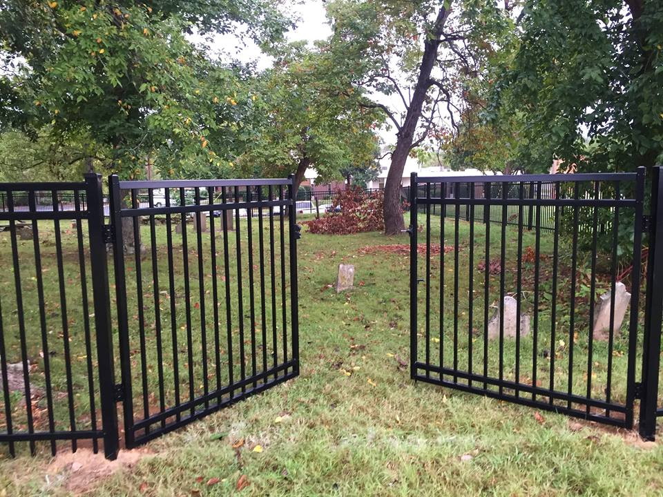
Entrance gate to Buchanan’s Station Cemetery (photo by Tim Slate)
On March 17, 2012, the Friends of Buchanan’s Station Cemetery met for the first time. Fostered primarily by the Buchanan Log House Chapter APTA, its president, Lu Whitworth, and historian Mike Slate, the grassroots group set its goals, which included effecting the transfer of the cemetery property from private ownership to Metro Nashville, fencing the unprotected graveyard, and acquiring signage for the education and inspiration of all visitors. From the beginning the Friends group worked closely with Tim Walker, executive director of the Metro Historical Commission.
On September 30, 2012, the Friends, assisted by Cumberland University and the French Lick Chapter of the DAR, held a major event at the cemetery commemorating the 220th anniversary of the Battle of Buchanan’s Station.
Lu Whitworth and Mike Slate, in period apparel, oversaw the event commemorating the 220th anniversary of the Battle of Buchanan’s Station, 9-30-2012. (NHN photo)
In 2015 businessman Scott Pope, working with group member Dick Davis, generously assigned the property to Metro Nashville. Later the same year the Friends, led by donations treasurer Joe Cathey, installed a quality fence around the historic graveyard and placed a comfortable bench inside. A grant from the Tennessee Wars Commission, facilitated by Tim Walker and David Currey, enabled some attractive interpretive signage to be added to the cemetery. (2017)
Hurt Drive, located off Elm Hill Pike in the Donelson suburb of Nashville, is for me the eeriest street in Davidson County. In the 1960s this half-mile-long road was part of my boyhood newspaper route, and some of my friends lived here in neat, moderately sized brick houses. Today nothing remains of that civilization except a ribbon of asphalt road.
Built during the 1950s Donelson boom, the subdivision that includes Hurt Drive thrived for about thirty years before the Metropolitan Nashville Airport Authority acquired it during its noise mitigation program of the 1980s and ’90s. (Indeed, today’s planes fly very low over this area.) The MNAA razed every house along Hurt Drive, carefully removed all rubble, constructed impressive masonry gates at both the north and south ends of the street, and generally returned the land to nature. Currently the agency keeps much of the grass cut while allowing a few lots to grow more freely.
The aforementioned gates, which inhibit vehicular but not pedestrian traffic, enhance the mysterious aura of the empty street. Arriving at the south gate, a visitor is roadblocked without any explanatory signage. May I walk along this road and enjoy it as a greenway path? Should I keep away from here altogether? Nothing answers such questions. However, around at the north gate a lonesome sign warns, “MOTORIZED VEHICLES PROHIBITED,” implicitly granting permission to walk the road. Yet visitors unacquainted with the area’s history are still faced with the overarching conundrum: why is this road here, since there’s nothing on it?
And what about the name itself, Hurt Drive (sometimes “Hurt Road”)? Where did that come from? Since “Hurt” is an esteemed local surname with area roots at least back to the War of 1812, my guess is that the road was named after the Hurt clan (or a member thereof). Hurt family members are buried in the nearby James Buchanan Cemetery; Benjamin Hurt was an area postmaster in the 1850s; Joe Hurt, also a postmaster, owned a grocery store at Lebanon Road and Donelson Pike around 1900; and Dr. Joseph Hurt was a well-known Donelson physician of recent years.
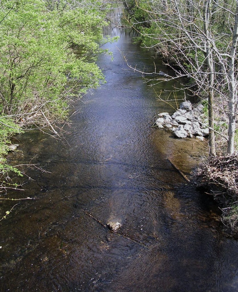
McCrory’s Creek flows immediately to the east of Hurt Drive. In fact, the ancient creek forms the back boundaries of some of the street’s lots, adding convincingly to Hurt Drive as a de facto greenway. Not surprisingly, “McCrory” is another eminent pioneer name. The specific individual for whom the creek was named is lost to history, but in 1792 Thomas McCrory helped repel the famous Indian attack at Buchanan’s Station, which was situated on Mill Creek, about three miles west of Hurt Drive down the present Elm Hill Pike. Although the McCrory family played a major role in the early development of the Davidson County area now known as Forest Hills, there are very few McCrorys remaining in the county today.
McCrory’s Creek (photo from NHN collection)
It’s nearly impossible for me to think of McCrory’s Creek without remembering the venerable Miss Jane Thomas. Her father settled along the creek in 1809 when Miss Thomas was nine years old. Later she helped establish a Methodist church nearby, raising money for a log building. When she was in her 90s, she wrote reminiscences in a series of newspaper articles, which were collected into a delightful, gossipy volume titled Old Days in Nashville. The important little sourcebook was first published in 1897, and reprints are still available today.
Virtually every Nashville historian is acquainted with Miss Thomas and her book, yet no one knows the precise location on McCrory’s Creek of either the Thomas home place or the Methodist church she helped found. If an enterprising researcher cannot pinpoint at least one of these and place an appropriate historical marker there, then perhaps a marker to the memory of the grand old lady could be erected on Hurt Drive, offering walkers something to read and contemplate.
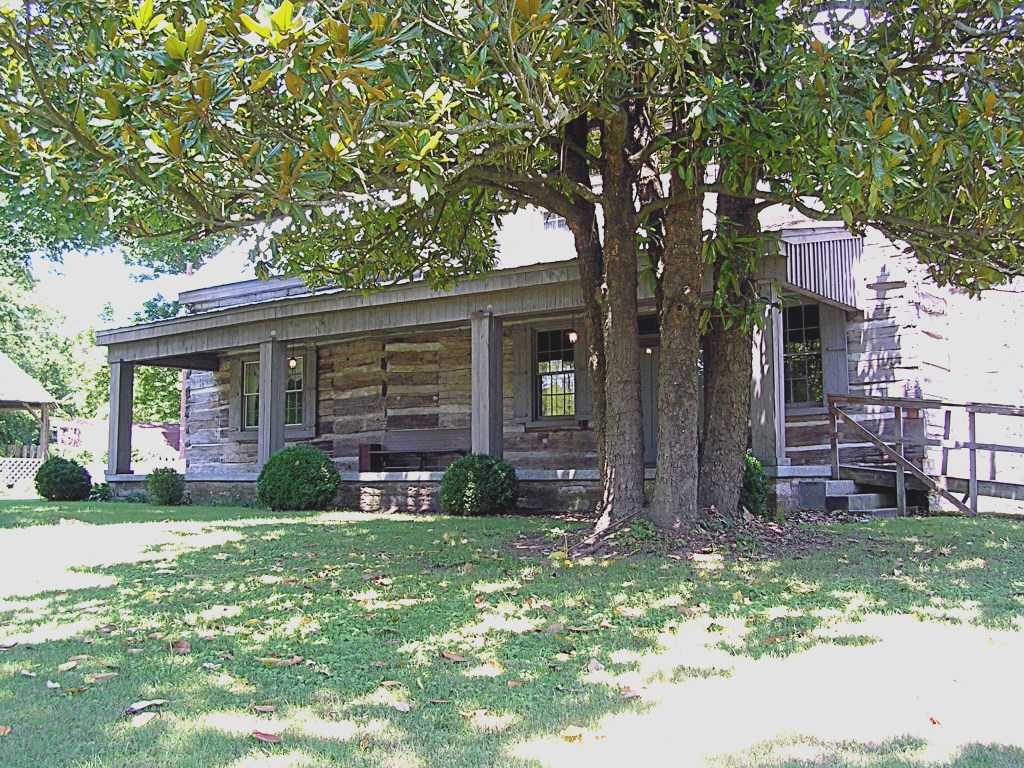
At Elm Hill Pike, Hurt Drive is sandwiched between McCrory’s Creek to the east and the Buchanan Log House to the west, giving visitors a triple treat in a single geographical spot. The landmark house, owned by the non-profit Association for the Preservation of Tennessee Antiquities (APTA), has in its front lawn a new Metro historical marker that describes the home and its circa 1807 origins. Branches of the local Buchanan family, however, stretch back even further than that, all the way to the very beginnings of Nashville. Two Buchanans signed the 1780 Cumberland Compact, and another died in the 1781 “Battle of the Bluffs” at Fort Nashborough. In addition, Maj. John Buchanan fought along with Thomas McCrory at the “Battle of Buchanan’s Station,” mentioned above.
Buchanan Log House (photo from NHN collection)
The log house marker also records the circa 1820 addition to the structure. It’s satisfying to imagine that, in addition to Buchanans, the enlargement project may have been watched or joined by members of the Thomas (perhaps by Miss Jane Thomas herself!), Hurt, and even McCrory families.
For lack of space the marker does not relate the important second ownership of the Buchanan House. After Buchanans had lived here for over fifty years, the place was purchased by Thomas Neal Frazier, an area judge. His son, who grew up here on the banks of McCrory’s Creek, was James B. Frazier. You might recognize that name, for he became governor of Tennessee in 1903 and a U.S. senator after that.
Hurt Drive, flanked by the Buchanan House and McCrory’s Creek, well illustrates the richness of Nashville history. Chapters of our heritage abound on every river, on every creek, and on almost every street or farm in the county . . . and all across Tennessee. Citizens who seek historical edification will likely find it right under their feet.
Source Note: A variety of written sources were consulted in the preparation of this article, but none were more helpful than two fonts of living knowledge: Debie Cox of the Metro Nashville Archives and Lu Whitworth of the Buchanan Log House.
This article was first published in the July 2009 issue of The Nashville Retrospect. We thank publisher Allen Forkum for his permission to republish it here.
Elm Hill Pike is one of the most historic roads in Nashville. Few thoroughfares in our city contain so much history packed into so few miles. The road, which probably began as a buffalo or Indian trail, has been mentioned in several accounts of early Nashville history. Andrew Jackson was reported to be a frequent traveler on Elm Hill Pike on his journeys from downtown Nashville to the Hermitage. Mapmakers and old-timers have also referred to this road as “the chicken pike” and the Stones River Road.
As you turn off of Murfreesboro Pike onto Elm Hill Pike, the first historic site encountered is Mt. Ararat Cemetery on the north. Mount Ararat was founded in 1869 by local black leaders and became a burial ground for many of Nashville’s black pioneers. Over the years, the cemetery became a dumping ground and a target for vandals. In 1982 the management of Mt. Ararat was taken over by the Greenwood Cemetery’s board of directors, which voted to change the name from Mt. Ararat to Greenwood Cemetery West and to begin a comprehensive restoration project.
About a mile east of Mt. Ararat Cemetery is Greenwood Cemetery, established on thirty-seven acres in 1888 by Preston Taylor. Taylor, born a slave in Louisiana in 1849, was an influential black preacher, undertaker, and business leader. In addition to Taylor, illustrious Nashville citizens buried at Greenwood Cemetery include Z. Alexander Looby, the Rev. Kelly Miller Smith, Sr., DeFord Bailey, John Merritt, and J. C. Napier.
The gates of Mt. Ararat Cemetery (photograph from NHN Collection)
In 1906 Preston Taylor opened Greenwood Park on approximately forty acres adjoining Greenwood Cemetery. The park was established to serve the black community and included a baseball stadium, skating rink, swimming pool, theater, merry-go-round, bandstand, zoo, and many other attractions. A state-wide fair and a Boy Scout summer camp were also held at Greenwood Park. The admission to the park was ten cents on regular days and twenty-five cents on holidays. The Fairfield-Green streetcar stop was nearby and horse-drawn wagons would pick up patrons and deliver them to the park’s entrance at Lebanon Road and Spence Lane. Preston Taylor died in 1931 and his wife managed the park until its closing in 1949.
Buchanan’s Station was located about another mile east where Mill Creek crosses Elm Hill Pike. The station was established by John Buchanan in 1780. Twelve years later, an oft-recounted Indian battle ensued. On a moonlit night in 1792, a band of three hundred Creek and Cherokee, under the leadership of Chiachattalla, raided the station. The twenty-one settlers fought bravely and defeated their attackers, killing Chiachattalla. Major Buchanan lived at the station until his death in 1832. He is buried, along with his wife and other settlers, in the station’s cemetery.
John and Sally Buchanan’s gravestones in Buchanan Station Cemetery. (from NHN Collection)
Peabody College established the Seaman A. Knapp School of Rural Life in 1915 on one hundred fifty acres on Elm Hill Pike. More acreage, including the site of Buchanan’s Station, was acquired in 1922. The farm was the first institution in the United States devoted to the study of the problems of rural life. Peabody College officials believed that teachers should become acquainted with agricultural life since so many of them would be teaching in rural areas. The experimental farm became a showplace with award-winning dairy and beef cattle herds. Innovative techniques in irrigation, pasturage and field equipment were tested at the farm; and many crops were raised including a certified corn station and a contoured, 25-acre orchard. Knapp Farm provided Peabody College with all its meat, vegetables, and fruit until World War II. The importance of the farm declined after the 1920s because of state-supported agricultural research. Expensive to maintain, Knapp Farm was sold in 1965 to a contractor who developed it into an industrial park.
Though the exact location of Mud Tavern is disputed, most old-timers agree that it was near the intersection of Elm Hill Pike and McGavock Pike. The tavern, built during Nashville’s youth, was made of cedar logs with a mud and stick chimney. Andrew Jackson was a frequent patron and it is reported that he spent two days there planning strategy in his duel with the ill-fated Charles Dickinson. Years later a community named Mud Tavern grew up in the area and contained a railroad station, school, post office, and grocery store. The Mud Tavern school building was used for many years as a clubhouse by the Elm Hill Community Club.
On the far side of Donelson Pike, at the corner of Elm Hill Pike and Hurt Drive, is the James Buchanan house. This two-story log house was built circa 1809. James Buchanan and his wife are buried in the family graveyard near the house, which is now under the care of the Association for Preservation of Tennessee Antiquities.
At the present time, Elm Hill Pike ends at Bell Road. The eastern-most part of the road has been re-engineered several times. The course of the road itself may change, but the history of Elm Hill Pike will always remain as a significant part of Nashville’s heritage. (2000)
Adapted by Kathy B. Lauder from the historical research of Nancy Helt and Josef Wilson, founding members of the Donelson-Hermitage Chapter of APTA, and Lu Whitworth, Buchanan-Whitworth researcher.
Members of the Buchanan family have been part of Nashville history from the beginning. Alexander Buchanan died in 1781 in the “Battle of the Bluff,” protecting Fort Nashborough from an Indian attack. Major John Buchanan was living in Buchanan’s Station by 1784. Archibald Buchanan moved his family to the area from Augusta County, Virginia, in 1785 to take charge of a 640-acre land grant called Clover Bottom. When Archibald died in 1806, his son James, who had spent his early years farming this land, inherited half the property (his uncle Robert Buchanan received the remainder), and purchased 310 additional acres from Thomas Gillespie’s original land grant “on Stone’s River.” This second property, which was not adjacent to Archibald’s grant, included the McCrory’s Creek area where James built what we now know as the Buchanan Log House. Eventually James Buchanan sold his share of Archibald’s property to John Hoggatt, who purchased the other half from Robert Buchanan’s heirs.
James was 46 years old when he finished the three-room log structure in 1809, about 50 years before the Two Rivers and Clover Bottom mansions were completed. A year after completing the house, James married 17-year-old Lucinda “Lucy” East and moved his young bride into the house, where the first of their sixteen children was born in 1811. Their home was one of the earliest log structures built in Middle Tennessee and is one of the few examples of two-story log construction still on its original foundation.
The original building exhibits construction techniques typical of frontier houses. Resting on solid unmortared limestone, the half-dovetail notched logs are chestnut, oak, and yellow poplar. The two-story single-pen original structure measures 18 by 26 feet, with exterior limestone gable-end chimneys flanked by double-hung sash windows. The two-room first floor has a 10-foot ceiling with exposed beaded poplar floor joists. A “ladder” stairway led to the upstairs room, which features a fireplace with an unusual arched limestone lintel marked by an incised keystone.
By 1820, after ten years of marriage, James and Lucy already had eight children. Needing more space, they constructed a one-and-a-half-story addition measuring 16 by 18 feet. This addition, with an exterior gable and a limestone chimney, created what is known as a saddlebag-type house. Even with the new section, the floor space still totaled only about 1430 square feet, into which they crowded eight more little Buchanans over the next few years. All sixteen children lived to adulthood, and many remained in the Donelson-Hermitage area, where a number of their descendants live today.
Because of the Buchanans’ land holdings and the number of slaves they held – about 15 – the family would have been considered quite wealthy for the period, falling into the upper 10% of the population.
When James Buchanan died at the age of 78 in 1841, he became the first person to be buried in the Buchanan Cemetery* across the road from the house. His tombstone carries this inscription:
Farewell my friends, as you pass by As you are now, so once was I As I am now, so you must be Prepare to die and follow me.
With the help of Addison, her fourth child, Lucy kept the farm going for another 24 years after her husband’s death. She died in 1865, at the age of 73, and was buried near her husband. Her epitaph echoes his:
As thou hast said, I follow you As all the rest must shortly do Then be not guilty of any crime So you may live in heaven sublime.
Her faithful son Addison received a 50-acre plot 1/4 mile east of the family home, where he built a two-room log house (one room downstairs, and one room up). This building has been moved to the 2910 Elm Hill Pike location, just behind the main log house. The move required “chopping” the roof so it could pass under the power lines, and taking the chimney apart, stone by stone, to be rebuilt at the new location. Renovating the Addison Buchanan house included removing the siding to expose the cedar logs and to repair or replace the chinking.
Soon after Lucy’s death, just as the Civil War ended, the property (except for the one-and-a-half-acre Buchanan cemetery) was purchased by Thomas Neal Frazier, a criminal court judge for Rutherford and Davidson counties. Frazier, a Union sympathizer, was impeached by the Tennessee General Assembly in 1866 for a conflict involving the 14th Amendment, but the impeachment was overturned in 1869. Judge Frazier’s son, James B. Frazier, who was a 10-year-old boy when the family moved into the log house, was elected governor of Tennessee in 1903. His administration is remembered primarily for advances in public education. He resigned as governor in 1905 to complete the term of U.S. Senator William B. Bate, who had died in office. Frazier was elected to three more terms in the Senate but lost to Luke Lea in 1911 and returned to his law practice in Chattanooga. Governor Frazier’s mother, Margaret McReynolds Frazier, lived on in the Log House until her death in 1910. Living with her were her daughter Sarah, with her husband John Harris, and Sarah’s brother Samuel J. Frazier, with his wife Fannie (Whitworth) and their son Neal, who later became a professor and dean at MTSU. Sarah, John, and Samuel, who lived on in the house for close to twenty years after Margaret’s death, all eventually died there. Neighbors referred to the house for years thereafter as the “Frazier place.”
Since 1927 the names on the mail box at 2910 Elm Hill Pike have included Payne, Richardson, Stark, Hudson, Keathly, Williams, and Greer, each of whom made a few changes and additions to the house. In May 1992 the property was purchased by the Metropolitan Nashville Airport Authority, who soon transferred it to the Association for the Preservation of Tennessee Antiquities (APTA), a statewide organization dedicated to the restoration and care of historic sites. Located seven miles from downtown Nashville, the Buchanan Log House is now managed by volunteers from the Donelson-Hermitage Chapter of APTA. Three of James Buchanan’s children married Whitworth siblings, and their descendants care for the Buchanan cemetery to this day.
*Note: this is not the same as the Buchanan’s Station Cemetery.