
Musings by Mike Slate.
Hurt Drive, located off Elm Hill Pike in the Donelson suburb of Nashville, is for me the eeriest street in Davidson County. In the 1960s this half-mile-long road was part of my boyhood newspaper route, and some of my friends lived here in neat, moderately sized brick houses. Today nothing remains of that civilization except a ribbon of asphalt road.
Built during the 1950s Donelson boom, the subdivision that includes Hurt Drive thrived for about thirty years before the Metropolitan Nashville Airport Authority acquired it during its noise mitigation program of the 1980s and ’90s. (Indeed, today’s planes fly very low over this area.) The MNAA razed every house along Hurt Drive, carefully removed all rubble, constructed impressive masonry gates at both the north and south ends of the street, and generally returned the land to nature. Currently the agency keeps much of the grass cut while allowing a few lots to grow more freely.

The aforementioned gates, which inhibit vehicular but not pedestrian traffic, enhance the mysterious aura of the empty street. Arriving at the south gate, a visitor is roadblocked without any explanatory signage. May I walk along this road and enjoy it as a greenway path? Should I keep away from here altogether? Nothing answers such questions. However, around at the north gate a lonesome sign warns, “MOTORIZED VEHICLES PROHIBITED,” implicitly granting permission to walk the road. Yet visitors unacquainted with the area’s history are still faced with the overarching conundrum: why is this road here, since there’s nothing on it?
And what about the name itself, Hurt Drive (sometimes “Hurt Road”)? Where did that come from? Since “Hurt” is an esteemed local surname with area roots at least back to the War of 1812, my guess is that the road was named after the Hurt clan (or a member thereof). Hurt family members are buried in the nearby James Buchanan Cemetery; Benjamin Hurt was an area postmaster in the 1850s; Joe Hurt, also a postmaster, owned a grocery store at Lebanon Road and Donelson Pike around 1900; and Dr. Joseph Hurt was a well-known Donelson physician of recent years.
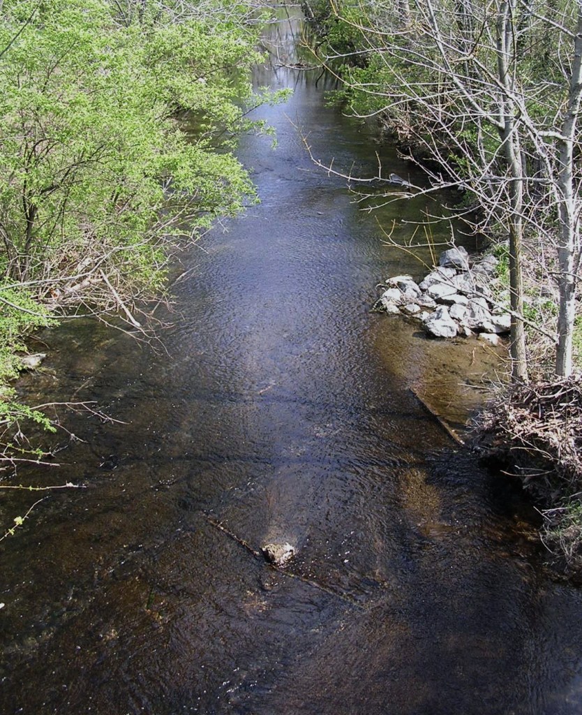
McCrory’s Creek flows immediately to the east of Hurt Drive. In fact, the ancient creek forms the back boundaries of some of the street’s lots, adding convincingly to Hurt Drive as a de facto greenway. Not surprisingly, “McCrory” is another eminent pioneer name. The specific individual for whom the creek was named is lost to history, but in 1792 Thomas McCrory helped repel the famous Indian attack at Buchanan’s Station, which was situated on Mill Creek, about three miles west of Hurt Drive down the present Elm Hill Pike. Although the McCrory family played a major role in the early development of the Davidson County area now known as Forest Hills, there are very few McCrorys remaining in the county today.
It’s nearly impossible for me to think of McCrory’s Creek without remembering the venerable Miss Jane Thomas. Her father settled along the creek in 1809 when Miss Thomas was nine years old. Later she helped establish a Methodist church nearby, raising money for a log building. When she was in her 90s, she wrote reminiscences in a series of newspaper articles, which were collected into a delightful, gossipy volume titled Old Days in Nashville. The important little sourcebook was first published in 1897, and reprints are still available today.
Virtually every Nashville historian is acquainted with Miss Thomas and her book, yet no one knows the precise location on McCrory’s Creek of either the Thomas home place or the Methodist church she helped found. If an enterprising researcher cannot pinpoint at least one of these and place an appropriate historical marker there, then perhaps a marker to the memory of the grand old lady could be erected on Hurt Drive, offering walkers something to read and contemplate.
At Elm Hill Pike, Hurt Drive is sandwiched between McCrory’s Creek to the east and the Buchanan Log House to the west, giving visitors a triple treat in a single geographical spot. The landmark house, owned by the non-profit Association for the Preservation of Tennessee Antiquities (APTA), has in its front lawn a new Metro historical marker that describes the home and its circa 1807 origins. Branches of the local Buchanan family, however, stretch back even further than that, all the way to the very beginnings of Nashville. Two Buchanans signed the 1780 Cumberland Compact, and another died in the 1781 “Battle of the Bluffs” at Fort Nashborough. In addition, Maj. John Buchanan fought along with Thomas McCrory at the “Battle of Buchanan’s Station,” mentioned above.

The log house marker also records the circa 1820 addition to the structure. It’s satisfying to imagine that, in addition to Buchanans, the enlargement project may have been watched or joined by members of the Thomas (perhaps by Miss Jane Thomas herself!), Hurt, and even McCrory families.
For lack of space the marker does not relate the important second ownership of the Buchanan House. After Buchanans had lived here for over fifty years, the place was purchased by Thomas Neal Frazier, an area judge. His son, who grew up here on the banks of McCrory’s Creek, was James B. Frazier. You might recognize that name, for he became governor of Tennessee in 1903 and a U.S. senator after that.
Hurt Drive, flanked by the Buchanan House and McCrory’s Creek, well illustrates the richness of Nashville history. Chapters of our heritage abound on every river, on every creek, and on almost every street or farm in the county . . . and all across Tennessee. Citizens who seek historical edification will likely find it right under their feet.
Source Note: A variety of written sources were consulted in the preparation of this article, but none were more helpful than two fonts of living knowledge: Debie Cox of the Metro Nashville Archives and Lu Whitworth of the Buchanan Log House.
This article was first published in the July 2009 issue of The Nashville Retrospect. We thank publisher Allen Forkum for his permission to republish it here.

