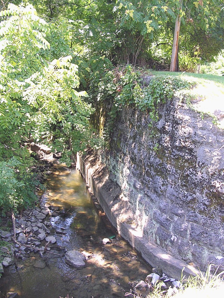
About half a mile south of the Stone’s River bridge on Lebanon Road, along the new greenway trail, you can peer across the river at the place where Stoner’s Creek empties into Stone’s River. If you know your history, you will stop dead in your tracks for a few moments, knowing that you have arrived at a historic location. The confluences of streams were landmarks for the pioneers and early historians . . . and no doubt for the Indians before them. Whereas we might say today that Central Pike is just past the Stone’s River bridge, the pioneers would more likely have said that a trail was just past the point where Stoner’s Creek flows into the Stone’s River.
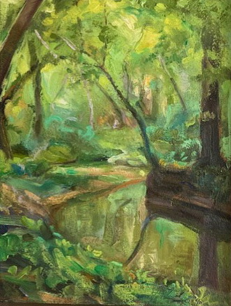
Painting by Fred Hetzel (from NHN collection)
Standing on that special spot and watching the Stoner rushing into the Stone awakens the realization that stream confluences are also confluences of lives: hundreds, maybe thousands, of folks have stood in this same area long before the greenway made it accessible to us greenhorn pathfinders. Uriah Stone, for whom Stone’s River was named, probably stood there. Michael Stoner, after whom Stoner’s Creek was named, surely scouted around that spot. I wish I could tell you that these two “long hunters,” so called because they explored and hunted for extended periods of time, met each other at that place and marveled together about the similarity of their surnames. That discussion may well have taken place, but probably not there. Both Stone and Stoner might have hunted in the Wellen party in the early 1760s, but that group did not follow the Cumberland as far west as its confluence with Stone’s River. It appears that the two pioneers explored our area at separate times in the late 1760s, about a dozen years before Nashville (or “Nashborough,” as it was first called) was founded.
Nashville co-founder John Donelson would probably also have stood on that spot. He planted corn in the adjoining bottom land, called “Clover Bottom,” and the Donelson family eventually lived nearby. No less an international dignitary than Andrew Jackson may very well have strolled that area himself, perhaps while his horses were warming up on the Clover Bottom race track. Another intriguing possibility is that Daniel Boone might have stood there. Boone and Stoner were not only compatriots but also close friends. Though I know of no record of a Boone visit to the Stone’s River, he could have come with Stoner at some point in time.
Photo by Paul Pierce
Nineteenth-century historians mention the existence of a Stoner’s Lick, located at some unspecified point on the creek. This would have been a salt lick, an area where salt or a salt rock outcrop rose to the surface. Such places were not just landmarks; they, like the French Lick around which Nashville was founded, were quite valuable in other ways. Buffalo and other game congregated at the licks, assuring easy access to meat and fur for the Indians, explorers, and settlers. Stoner’s Creek winds much farther east than it appears to on some maps [Stoner Creek Elementary School in Mt. Juliet, destroyed by the March 2020 tornado, is currently being rebuilt (2021)], so the lick could have been anywhere along several winding miles. For example, since buffalo trails often became roads for the settlers, the lick could have been approximately at the intersection of today’s Central Pike and Stoner’s Creek. Perhaps the driveway to the emissions inspection station is astride the lick! At least we still have the confluence, since the lick is probably lost forever.
I will conclude these musings with a linguistic grumble: Stone’s River and Stoner’s Creek do not exist on modern maps. Oh, the streams are there, all right, but the names have changed. Although most nineteenth-century historians wrote both names in the possessive form, somewhere along the way the apostrophes dropped off. Considered acceptable now are “Stones River” and “Stoners Creek,” despite the fact that the long hunters’ names were Stone and Stoner. I will hazard a guess that the corruption occurred first on maps, for lack of space or accuracy, and then continued on into texts. However it happened, if you drive out Lebanon Road and cross the Stone’s River bridge today, you will see a sign that reads “Stones River.” Feel free to smile at that sign, realizing that you know better.
Note: In 2011 a reader informed us that his ancestor Thomas Wilson bought this land from James Rucker in 1805. Wilson died in 1811, but his sons lived there until the 1830s and then migrated to Memphis. One of his daughters married William Creel, and another married Timothy Dodson.
The Clover Bottom Mansion, Donelson, built in 1858, is currently home to the Tennessee Historical Commission
Events of the past continue to shape our lives today, and the prosperous era of the 1850s is a case in point. In 1850 the first locomotive arrived in Nashville, sustaining and enhancing the city as a regional commercial and metropolitan hub, a standing we have never relinquished. Today’s Union Station, built at the turn of the century during the railroad boom, survives as one of our most beloved cultural landmarks.
Nashville’s Union Station opened in October 1900 as a Louisville & Nashville Railroad station.
The Medical School of the University of Nashville opened in 1851, met with immediate success, and quickly established Nashville as a medical center. Following in its wake, Shelby Medical College opened in 1858. The Nashville medical tradition continued with Vanderbilt University, which today provides one of America’s finest medical centers.
The Medical Department of the University of Nashville opened on Second Avenue South in 1851. It would become part of Vanderbilt University in 1874, forming the nucleus of what is today the Vanderbilt University School of Medicine.
In 1854 the publishing arm of the Methodist Episcopal Church South opened on the public square, securing Nashville’s future as a publishing mecca. No doubt the presence here of the Methodist Publishing House played a part in the 1870s formation of Vanderbilt University, which began as a Methodist school. Still in operation today and publishing under several imprints, the publishing house has employed thousands of Nashvillians and pumped millions of dollars into our economy.
In 1873 Cornelius Vanderbilt, known as “the Commodore,” endowed the city of Nashville with $1 million to establish and build the university that today bears his name. The old “Main Building” (pictured above) was dedicated in 1875. Nearly destroyed by fire in 1905, the structure was rebuilt in Italianate style crowned with a single tower and renamed Kirkland Hall in honor of Chancellor James Hampton Kirkland.
Nashville’s first public school was named in honor of educator Alfred Hume, who has been called “the father of Nashville public schools.” Hume School opened in 1855 with 12 teachers. From that modest beginning developed the sprawling Metro Nashville public school system with a total proposed operating budget for the 2021-2022 fiscal year of $1,017,807,500, which provides for 157 schools, 86,000 students, and 11,000 employees.
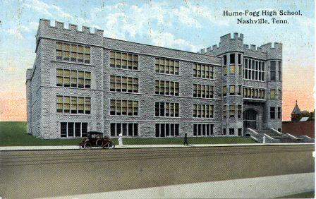
The Hume School, Nashville’s first public school, opened in 1855 for grades 1-12. In 1874 the high school students moved to the Fogg High School, newly built on an adjoining lot fronting Broad Street. In 1912 the two schools merged and moved into this Gothic Revival building designed by architects William Ittner and Robert Sharp.
The Tennessee State Capitol, completed in 1859, is the governmental temple in which our state laws are still sanctified. Other structures built in the 1850s that contribute to Nashville’s present character include Downtown Presbyterian Church (dedicated in 1851), Holy Trinity Episcopal Church (1852), Sunnyside Mansion (ca. 1852), Belmont Mansion (1853), Literary Building of the University of Nashville (1853), Church of the Assumption (completed in 1859), Clover Bottom Mansion (1859), and Two Rivers Mansion (1859).
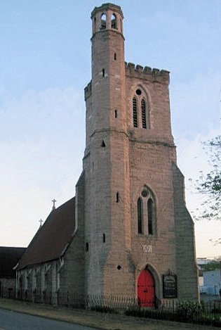
Holy Trinity Church, located on 6th Ave. S at Lafayette, became an Episcopal parish in 1851. The building was occupied by Federal troops during the Civil War and received considerable damage. Restored after the war, it has served the African American community for decades.
These and other events from 150 years ago belie any notion that history is irrelevant. The past has not only a chronological relationship with the present but also a causative one. We did not just happen upon the present: the past is the impetus for today.
All postcards and photographs used in this article are part of the NHN collection.
One of the most popular features of the Donelson area is a paved greenway trail system along the banks of Stone’s River from the Percy Priest Dam to the Cumberland River. The trail winds through the Clover Bottoms, an area of prime importance to the early settlers in the Nashville area.
Scene on the greenway trail (from NHN collection)
The pioneer story began in 1766 with the exploration of the Long Hunters. The river was named in honor of one of their group, Uriah Stone. These adventurers carried the story of this bountiful, uninhabited land with them when they returned to Virginia and North Carolina. It was fourteen years, however, before the first settlers arrived.
In the spring of 1780, John Donelson, having led the flotilla of settlers to Nashborough, recognized the need to plant a corn crop immediately. He again boarded the good ship Adventure with his family, poled up the Cumberland around the great bend until he found the mouth of Stone’s River. He was looking for alluvial fields that were as fertile as the Valley of the Nile and which needed no clearing in order to plant.
The Donelson Party arrived on flatboats
A short distance from the confluence of the two rivers he found what he was looking for on the west bank of Stone’s River*, an area forever after known as the Clover Bottoms. Here he docked his boat and built half-faced shelters to house his family on the opposite bluff. This was fifteen-year-old Rachel Donelson’s first home in Tennessee.
That July heavy rains inundated the corn crop. This unhappy event, plus constant harassment from the native Indians, forced the family to move to Mansker’s Fort for protection.
By fall, word reached the settlers at Mansker’s that the flood waters had subsided and that the corn had eared. John Donelson sent a request to the men at Fort Nashborough to meet him at the Clover Bottoms to help harvest the corn. Approximately ten men from each fort built wooden sleds to drag the corn from the field to the boats moored in Stone’s River. Several days were required to load the boats.
As they left the shore, the boat from Fort Nashborough was attacked by Indians; only three settlers escaped with their lives. The Donelson party was on the north bank, harvesting the cotton planted there. They abandoned their boat loaded with corn and managed to get away on foot through the woods. Donelson’s heroic slave, Somerset, swam the Cumberland River and brought help from Mansker’s Fort to the stranded group.
Meanwhile, the boat from Fort Nashborough floated downstream, eventually reaching the bluffs with its tragic cargo of corn and slain men. The settlers there rescued the corn and buried their dead.
Some years later Andrew Jackson, who had married Rachel Donelson, operated several businesses along the Stone’s River corridor. He first opened a general store near the Clover Bottoms. In order to stock his store, he went to Philadelphia and traded land preemptions for flour, sugar, piece goods, and pocket knives. The store was a two-story building near today’s Downeymead Drive. C. Lawrence Winn, a descendant of Jackson’s adopted son, built a house on the property in 1960.
In 1805 Jackson, with two partners, formed the Clover Bottom Jockey Club. A race track and tavern were built by the river. The story of Jackson’s duel with Charles Dickinson is well known. The unfortunate quarrel that sparked the duel started at this race track.
A story that is not so well known is that of Jackson’s boat yard on Stone’s River, near its mouth. Here he constructed five flat boats and one keel boat for former Vice President Aaron Burr who was leading a group of colonists to lands he had acquired in Louisiana. In 1812 Andrew Jackson became a military officer and began his lengthy pursuit of both a military and a political career. Thereafter his business interests on Stone’s River faded away.
A Donelson creek (from NHN photo collection)
The large tract of land known as Clover Bottom Plantation came to be owned by Dr. James Hoggatt, who built the ante-bellum mansion on the property. The property was sold to Mr. Andrew Price in the late 19th century, and then to A.F. and R.D. Stanford in the early 20th century. After World War II it was sold to the State of Tennessee.
Although the last several years have brought considerable business development to the Clover Bottoms, much of the river bank remains untouched by man. The Greenway Project is a promise to maintain the natural beauty of this historic site and preserve it for our future generations. (2000)
* Historians surmise that John Donelson’s cornfield was located just west of the Stone’s River bridge, in the general area of today’s Jackson Downs (Target) shopping center, which was named, incidentally, for the racetrack Andrew Jackson later built slightly northeast of that location.
Nashville began to attract streams of visitors almost from the moment it became a frontier trading post. As time passed, tourists and settlers came for the music and theatre and food, for history and politics and education, for the casual atmosphere and friendly people. It was educator Philip Lindsley (1785-1855) who first referred to Nashville as the “Athens of the South” (Philip actually said “Southwest”), for the city has long been a center of educational and cultural activities. And high on the list of attractions is the intriguing variety of architectural styles to be discovered here.
One’s first impression of Nashville, the downtown skyline, features the “Batman” and “R2-D2” building silhouettes, several tall hotels and banks, and the dear old L&C Tower, whose 31 floors made it, at the time of its 1957 opening, the “tallest commercial structure of its day in the Southeastern United States.”1 Church Street and Broadway feature some of our most interesting church buildings: the First Baptist Church; Christ Church Episcopal; McKendree Methodist, its earlier façades buried beneath layers of renovations; Downtown (First) Presbyterian with its rich and compelling history; and, a little farther out, the graceful Holy Trinity Episcopal Church on Sixth Avenue.
This 1880-era photograph, taken from the State Capitol looking east, shows the railroad bridge over the Cumberland River and the steeple of Second Presbyterian Church (right center), which stood on 3rd Avenue near where the Criminal Justice Center stands today. (TSLA photograph, used by permission)
Many tourists come to Nashville specifically to visit historic homes, and the city has a lovely collection of these as well: The Hermitage, fourth most-visited Presidential home in America (after the White House, Mount Vernon, and Monticello); Belmont, former home of one of the country’s richest women, and now the centerpiece of the Belmont University campus; Belle Meade and Travellers Rest, renowned for the breeding of magnificent horses; Cheekwood, with its exquisite gardens and galleries; and the wedding-cake charm of Clover Bottom and Two Rivers. Equally unforgettable are the stand-alone architectural delights of the Tennessee State Capitol, the Customs House, Union Station, Ryman Auditorium, and the splendid Parthenon, the crowning glory of Centennial Park and the only full-scale replica of the ancient Athenian temple in the world.
Yet if we could visit the Nashville of earlier days, we would be astonished, not only at the number of public buildings that have been transformed into more modern spaces, but also at the number that have disappeared forever.
Not all the stories have tragic endings, of course. Union Station was saved from impending destruction a few years ago, as was the Ryman. Moreover, the Metropolitan Historical Commission encourages preservation activities by presenting a number of awards each year to individuals and groups who have rescued and restored public or private structures throughout the city. But the very word “progress” conjures up an image of bulldozers, and Nashville, like many American cities, has seen far too many beautiful buildings destroyed to make room for, among other things, motels and parking lots!
One of the city’s loveliest lost buildings was the Second Presbyterian Church, once part of our riverfront skyline, but now only a fading image in a handful of old photos. The church stood on Third and Gay Streets, not far from the spot where the James Robertson Parkway crosses Third Avenue before swooping across Victory Memorial Bridge. Dr. John Todd Edgar and Dr. Philip Lindsley spoke at the church’s 1844 dedication.2
There are significant differences of opinion about the history of “2nd Pres,” as John Berrien Lindsley called it in his 1859 diary.3 Many Nashvillians believe that William Strickland, architect of the Capitol, designed the church. However, according to James Patrick, author of Architecture in Tennessee, 1768-1897, the architect was James M. Hughes, a man the Nashville City Directory lists as a carpenter.4 Patrick refers to a silver plate deposited in the cornerstone of the church naming Hughes as the architect. In 1844 the Nashville Whig listed the full text of the inscription:
The Second Presbyterian Church of Nashville, OLD SCHOOL. erected in the year of our lord 1844. Rev. Robert A. Lapsley, Pastor. Samuel Seay, William B. Shapard, William H Marquess, James M. Hamilton, and Adam G. Adams, Elders. Samuel Hill, Foster Williams, Abram Stevens, and John McCrea – Deacons. Organized February, 1844, with 32 Members. JOHN TYLER, President of the United States. James C. Jones, Governor of Tenn. P.W. Maxey, Mayor of Nashville. Population of Nashville, 8,000. James M. Hughes, Architect. Engraved by D. Adams.5
Adding further weight to Patrick’s assertion, Nell Savage Mahoney, a lifelong student of Strickland’s work, omits Second Presbyterian from her list of his creations.
Support for Strickland’s involvement, however, may be found in “William Strickland, Architect,” a 1986 article from the Tennessee Historical Quarterly. Author James A. Hoobler, Curator of the Capitol, compares the altar area of the Second Presbyterian Church with a Strickland drawing labeled “Second Presbyterian.” 6 The structural similarities of shape and dimension cannot be denied. (Hoobler has also discovered compelling evidence that St. Mary’s Roman Catholic Church, long attributed to William Strickland, was, in fact, built by Adolphus Heiman, but that’s a story for another day.)
Actually, a fairly strong case can be made for the possibility of a collaboration between the two men, with Strickland as teacher/adviser and Hughes as apprentice/contractor. Mahoney herself provides evidence of an earlier such alliance between Strickland and one of his students. Strickland is believed to have drawn the original elevation used by his former pupil Thomas U. Walter when the younger man was appointed to design a building for the Girard College campus in Philadelphia.7
Further evidence of a Strickland-Hughes partnership comes from Circuit Court records, January term 1857. Strickland had been engaged by H.R.W. Hill “to serve as an architect for and superintend the erection of a Methodist church [in New Orleans] . . .. William [Strickland] was put to great expense in going to and from said city during the progress of said work . . .. The church was built at the same time that the St. Charles Hotel was erected – both the St. Charles and the Methodist Church on Pozdras street were burned in February, 1850 . . .. Strickland and Hughes were here at the time, as this witness learned from Hughes, to get a contract for [re]building the St. Charles.”8
So even finding James Hughes’ name inside the cornerstone does not rule out the possibility that the original drawings for Second Presbyterian came from Strickland.
Newcomers may wonder why William Strickland’s buildings are so valuable. In fact, many people consider them national treasures – Strickland is widely considered to be one of the most influential architects of the nineteenth century. Prior to his move to Nashville, he built so many notable buildings in Philadelphia, he was sometimes called “the city architect.”9 Among his important designs there are the Second Bank of the United States (His best-known portrait places him in front of the Bank, which strongly resembles the Parthenon.); the Merchants Exchange; St. Stephen’s Church; Masonic Hall; and dozens more. In Nashville Strickland contributed to the design and re-design of many private homes, burial monuments, and a wide variety of public buildings. Best known, however, are the Downtown (First) Presbyterian Church – now widely considered America’s finest surviving example of church architecture in the Egyptian Revival style – and his masterpiece, the Tennessee State Capitol. Many of Strickland’s buildings have been designated National Historic Landmarks.
In 1902, convinced that the neighborhood was becoming too commercial, the Second Presbyterian congregation sold the building and relocated to North Nashville, moving again in 1929 to better oversee the Monroe-Harding Children’s Home in Green Hills.10 They left behind not only the classical simplicity of the building’s exterior, but also the beautiful interior, which included a painted fresco behind the altar suggesting a classical porch with a view of distant hills, and a network of intricate trompe l’oeil panels and columns adorning the ceiling and walls. For many years thereafter, the original building – described at the time of its dedication as a “new and beautiful edifice . . . an ornament to that part of the city”11 – was used by the Standard Candy Company as a warehouse.12
By the late 1970s the church building had become the property of Metro Nashville. The city’s plans to build a new Criminal Justice Center involved razing the old church and other nearby structures. Although preservation advocates from the Metropolitan Historical Commission and the Tennessee State Museum pleaded with city officials to be permitted at least to salvage significant architectural elements from the building, their requests were denied.13 In 1979 Nashville’s historic Second Presbyterian Church was bulldozed into rubble in order to provide a handful of parking spaces for the Criminal Justice Center.
Sources consulted:
1 Zepp, George. “Nashville L&C Tower once offered bird’s-eye view of Nashville,environs,” Nashville Tennessean, 16 Feb 2005.
2 Nashville Whig, April 27, 1844.
3 Lindsley Family Papers, ca. 1600-ca. 1940. Tennessee State Library and Archives.
4 Patrick, James. Architecture in Tennessee, 1768-1897. Knoxville: University of Tennessee Press, 1981.
5 Nashville Whig, April 27, 1844.
6 Hoobler, James A. “William Strickland, Architect,” Tennessee Historical Quarterly, Spring 1986.7 Mahoney, Nell Savage (1889-1986) Papers, 1825-1972. THS Acc. No. 457 & 681. Tennessee State Library and Archives.
12 Hoobler, James A. A Guide to Historic Nashville, Tennessee. Charleston, SC: The History Press, 2008.
13 Hoobler, James A. A Guide to Historic Nashville, Tennessee.
This article was first published in The Nashville Retrospect. We thank publisher Allen Forkum for his permission to republish it here. Much gratitude also to Jim Hoobler, Cathi Carmack, Lori Lockhart, and Mike Slate for helping me untangle the knotted threads of this story. KBL
In the 1920s Lebanon Road ran through the Clover Bottom farm property and crossed Stone’s River just west of the present road and bridge. The old stone bridge abutments are still standing. The Stanford brothers, A.F. and R.D., had purchased the farm in 1918. Since Lebanon Road split the property, A.F. took the section to the east of the road and R.D. took the section to the west. A.F.’s part included the antebellum Hoggatt residence and R.D. built a two-story brick colonial revival home on his side of the road.
In the period following World War I the outlying areas of Davidson County were still rural farm lands. A.F. Stanford ran a dairy farm at Clover Bottom while R.D. Stanford raised white-faced beef cattle. The majority of the population of the county, however, lived within the confines of the Nashville city limits. With the proliferation of the family motor car in the “Roaring Twenties,” excursions to the countryside became a popular pastime. For those fortunate enough to own an automobile, exploring country roads, farms, and creek sides was a welcome relief from city life. There was usually a picnic basket on board filled with fried chicken, biscuits that had been buttered while hot, stuffed eggs, and a special Nashville favorite, chess pie.
Finding a swimming hole in one of the area rivers or creeks was an extra bonus on these outings. Although Mill Creek and Richland Creek were good for wading, neither furnished very deep holes for swimming. Men and boys swam in the Cumberland River, but it was considered too dangerous for women and children. The best swimming spots were found in the Harpeth and Stone’s rivers.
Clover Bottom beach house. Photo courtesy of the author.
One such spot on Stone’s River was on A.F. Stanford’s side of the old bridge near where the present-day bridge crosses. Mr. Stanford created a beach by having tons of sand hauled in. He constructed a frame beach house with dressing rooms, lockers, and showers. There were boats, springboards, and picnic tables. He even employed Mr. and Mrs. M.B. Hall to manage the beach operation. Mr. Stanford’s generosity in creating this community beach is documented in a 1927 advertisement which stated that everything was free. It also stated that Old Hickory busses passed every thirty minutes—fare twenty-five cents.
Advertisement for Clover Bottom Beach, 1927, courtesy of the author.
When the new bridge was constructed in the early 1930s, the old road leading to the beach entrance was closed. The new bridge piers were sunk into the the swimming hole and floods washed away the sand. All that remains of the once-lively recreational spot are photographs taken by Wiles Studio in 1931, now in the collection of Merle Stanford Davis who married A.F. Stanford in 1927 and was mistress of Clover Bottom until 1948. She has generously shared her recollections for the publication of this article. (2000)
Entrance to Clover Bottom Beach. Photo courtesy of the author.
Adapted by Kathy B. Lauder from the historical research of Nancy Helt and Josef Wilson, founding members of the Donelson-Hermitage Chapter of APTA, and Lu Whitworth, Buchanan-Whitworth researcher.
Members of the Buchanan family have been part of Nashville history from the beginning. Alexander Buchanan died in 1781 in the “Battle of the Bluff,” protecting Fort Nashborough from an Indian attack. Major John Buchanan was living in Buchanan’s Station by 1784. Archibald Buchanan moved his family to the area from Augusta County, Virginia, in 1785 to take charge of a 640-acre land grant called Clover Bottom. When Archibald died in 1806, his son James, who had spent his early years farming this land, inherited half the property (his uncle Robert Buchanan received the remainder), and purchased 310 additional acres from Thomas Gillespie’s original land grant “on Stone’s River.” This second property, which was not adjacent to Archibald’s grant, included the McCrory’s Creek area where James built what we now know as the Buchanan Log House. Eventually James Buchanan sold his share of Archibald’s property to John Hoggatt, who purchased the other half from Robert Buchanan’s heirs.
James was 46 years old when he finished the three-room log structure in 1809, about 50 years before the Two Rivers and Clover Bottom mansions were completed. A year after completing the house, James married 17-year-old Lucinda “Lucy” East and moved his young bride into the house, where the first of their sixteen children was born in 1811. Their home was one of the earliest log structures built in Middle Tennessee and is one of the few examples of two-story log construction still on its original foundation.
The original building exhibits construction techniques typical of frontier houses. Resting on solid unmortared limestone, the half-dovetail notched logs are chestnut, oak, and yellow poplar. The two-story single-pen original structure measures 18 by 26 feet, with exterior limestone gable-end chimneys flanked by double-hung sash windows. The two-room first floor has a 10-foot ceiling with exposed beaded poplar floor joists. A “ladder” stairway led to the upstairs room, which features a fireplace with an unusual arched limestone lintel marked by an incised keystone.
By 1820, after ten years of marriage, James and Lucy already had eight children. Needing more space, they constructed a one-and-a-half-story addition measuring 16 by 18 feet. This addition, with an exterior gable and a limestone chimney, created what is known as a saddlebag-type house. Even with the new section, the floor space still totaled only about 1430 square feet, into which they crowded eight more little Buchanans over the next few years. All sixteen children lived to adulthood, and many remained in the Donelson-Hermitage area, where a number of their descendants live today.
Because of the Buchanans’ land holdings and the number of slaves they held – about 15 – the family would have been considered quite wealthy for the period, falling into the upper 10% of the population.
When James Buchanan died at the age of 78 in 1841, he became the first person to be buried in the Buchanan Cemetery* across the road from the house. His tombstone carries this inscription:
Farewell my friends, as you pass by As you are now, so once was I As I am now, so you must be Prepare to die and follow me.
With the help of Addison, her fourth child, Lucy kept the farm going for another 24 years after her husband’s death. She died in 1865, at the age of 73, and was buried near her husband. Her epitaph echoes his:
As thou hast said, I follow you As all the rest must shortly do Then be not guilty of any crime So you may live in heaven sublime.
Her faithful son Addison received a 50-acre plot 1/4 mile east of the family home, where he built a two-room log house (one room downstairs, and one room up). This building has been moved to the 2910 Elm Hill Pike location, just behind the main log house. The move required “chopping” the roof so it could pass under the power lines, and taking the chimney apart, stone by stone, to be rebuilt at the new location. Renovating the Addison Buchanan house included removing the siding to expose the cedar logs and to repair or replace the chinking.
Soon after Lucy’s death, just as the Civil War ended, the property (except for the one-and-a-half-acre Buchanan cemetery) was purchased by Thomas Neal Frazier, a criminal court judge for Rutherford and Davidson counties. Frazier, a Union sympathizer, was impeached by the Tennessee General Assembly in 1866 for a conflict involving the 14th Amendment, but the impeachment was overturned in 1869. Judge Frazier’s son, James B. Frazier, who was a 10-year-old boy when the family moved into the log house, was elected governor of Tennessee in 1903. His administration is remembered primarily for advances in public education. He resigned as governor in 1905 to complete the term of U.S. Senator William B. Bate, who had died in office. Frazier was elected to three more terms in the Senate but lost to Luke Lea in 1911 and returned to his law practice in Chattanooga. Governor Frazier’s mother, Margaret McReynolds Frazier, lived on in the Log House until her death in 1910. Living with her were her daughter Sarah, with her husband John Harris, and Sarah’s brother Samuel J. Frazier, with his wife Fannie (Whitworth) and their son Neal, who later became a professor and dean at MTSU. Sarah, John, and Samuel, who lived on in the house for close to twenty years after Margaret’s death, all eventually died there. Neighbors referred to the house for years thereafter as the “Frazier place.”
Since 1927 the names on the mail box at 2910 Elm Hill Pike have included Payne, Richardson, Stark, Hudson, Keathly, Williams, and Greer, each of whom made a few changes and additions to the house. In May 1992 the property was purchased by the Metropolitan Nashville Airport Authority, who soon transferred it to the Association for the Preservation of Tennessee Antiquities (APTA), a statewide organization dedicated to the restoration and care of historic sites. Located seven miles from downtown Nashville, the Buchanan Log House is now managed by volunteers from the Donelson-Hermitage Chapter of APTA. Three of James Buchanan’s children married Whitworth siblings, and their descendants care for the Buchanan cemetery to this day.
*Note: this is not the same as the Buchanan’s Station Cemetery.