Six Triple-Threat Town Sites

by Guy Alan Bockmon.

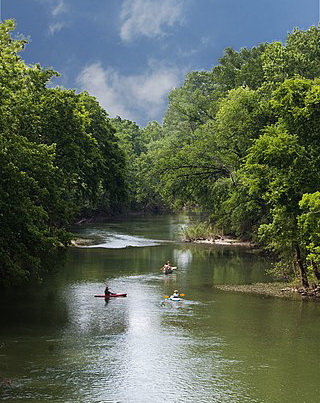
In his 1930 book Soil, Its Influence on the History of the United States, Archer Butler Hulbert noted that the locations of the early “ferries . . . mark the . . . points where the ancient trails descended from high ground to the fords. These were usually located on a river at the mouth of a loading tributary. The sediment of this tributary was deposited blow [sic] its mouth in the main river, making the water shallower at that point and therefore more easily forded. About such fords human habitations usually sprang up in the shape of trading cabins, villages, or forts.”

At six such sites there sprang up the first tiny villages on the Cumberland and Red Rivers in Middle Tennessee.

The village of Nashville grew up around the 1780 fort sited on a defensible bluff accessible from the river via Lick Branch. The Lick Branch shoal was augmented by that of Pond Branch, which flowed into the Cumberland from the opposite side.

A little more than a mile downstream from Nashville, and on the other side of the river, Heaton’s (or Eaton’s) Station was also established in 1780, at a location near where Well’s Mill Creek loaded into the Cumberland. The station had prospered sufficiently to be called Heatonsburg in the 1783 minutes of the Notables. Historian A. W. Putnam (1799-1869) believed the town of Waynesborough was laid out at Heaton’s Station about 1796. This new town, a rival to Nashville, was given its name in honor of General Anthony Wayne.

Clarksville, the second settlement in Middle Tennessee to survive as a town, was sited on the east bank of the Cumberland, just above the mouth of the Red River. Local historian W. P. Titus observed that Clarksville had the advantages of two rivers, good landings, and, what was then indispensable, a gushing spring of pure water.

A few miles downstream from Clarksville, Deason and Weaver Creeks had combined forces over geological time, carving a deep notch into the high limestone bluff. At that spot on the south shore, downstream from the mouth of the north shore’s Hog Branch, the village of Palmyra began to prosper in its role as the country’s international port nearest to the Gulf of Mexico. Jonathan Steele, Comptroller of the Treasury from 1796-1802, noted that the appointment of one Morgan Brown as Collector had been approved upon the information of Andrew Jackson, then a Senator from Tennessee.

About ten miles east of Clarksville, where Sulphur Fork Creek flows into the Red River, the village of Port Royal was laid out, as described by C. E. Brehm*, into 37 lots, four streets, a public square and a section of land reserved for a public warehouse.

Upstream from Nashville about six miles is the mouth of Spencer’s Spring Branch. It was later to be called, successively, Buchanan’s Spring Branch, Craighead’s Spring Branch, and Love’s Spring Branch. On its banks by 1799 was established the village of Haysborough.

Only a few fords and ferries are still in use, as are even fewer portages. The cities of Nashville and Clarksville still thrive. Palmyra still exists. The site of Port Royal is now a State Park. The historic villages of Haysborough and Waynesboro have disappeared from modern maps. The triple threat of fording place, portage, and harbor at these six sites and many others largely determined where future settlements, roads, ferries, bridges, and eventually railroads would be located. Thus did sedimentation influence settlement.


* Cloide Everett Brehm (1889-1971) was president of the University of Tennessee from 1946-1959.

Big Harpeth River

by Ilene Jones Cornwell.

Middle Tennessee’s Big Harpeth River drains a basin of 895 square miles. With headwaters in southwestern Rutherford County, the river meanders in a generally northwest direction through the counties of Williamson, Davidson, and Cheatham. The tree-lined waterway is fed by several tributaries–West Harpeth, Little Harpeth, and South Harpeth–as well as Trace, Brush, Turnbull, and Jones creeks. The river flows in loops and lazy curves about 118 miles before its confluence with the Cumberland River near Ashland City.

Harpeth River

The earliest recorded descriptions of the river we know as Big Harpeth mention its abundance of fish and the fertility of the soil along its course. Surveyor Thomas Hutchins labeled the river in 1768 as Fish Creek, apparently an appropriately descriptive name. Traveler John Lipscomb noted in his journal of 1784 that the wild cane along the river was “so thick a man could scarcely ride”; a profusion of wild cane indicated fertile soil, since cane grew in the most productive earth.

The name Fish Creek remained with the river until the 1780s, when the stream was shown on maps as the Harpath. The name continued to be spelled H-a-r-p-a-t-h as late as 1796, when the Map of the Tennessee Government, Formerly Part of North Carolina was published in Philadelphia. By the early 1800s, however, the name’s spelling had changed to Harpeth and that spelling appeared on nineteenth-century maps and in publications and correspondence. Pioneer surveyor John Davis, who had claimed a land grant “about twelve miles southwest of Nashville” and settled on Big Harpeth after the Revolutionary War, gave as his address in 1851 that of “Harpeth, Davidson County, Tennessee.”

Whether Harpath or Harpeth, what does the word mean and why was it applied to this beautiful stream in Middle Tennessee? Several theories have been offered, but the conjecture that seems to be most plausible is that the river was named by early Tennessee settlers for a mythical stream in English literature. Edward D. Hicks IV, a descendant of pioneer John Davis, read a paper entitled “Origin of the Name Harpeth” in 1892 to members of the Tennessee Historical Society in Nashville. He referred to an “Oriental legend” published by editor Joseph Addison in the August 23, 1714, issue of The Spectator, a popular London periodical. “Among our early settlers were some, if not many, scholarly men,” said Hicks. “Books were not so abundant then as now, but to these gentlemen the classics were as familiar as household words, and The Spectator was an English classic.”

In the legend there were two brothers, Harpath and Shalum, who lived in China and became rivals for the affection of a beautiful woman named Hilpa. After Harpath won the hand of lovely Hilpa, Shalum cursed him and prayed for a mountain to fall upon his brother. Harpath fearfully avoided the mountains, hoping to prevent such harm to himself, but he eventually drowned in a river issuing from the mountains and the river was forever called Harpath.

However the Harpeth River acquired its name, the winding waterway served as a magnet for the earliest settlers of southwestern Davidson County and is both a mythical and tangible part of the heritage of Middle Tennessee. The Harpeth by any other name would be just as scenic and historic.

Across the Harpeth Valley from the Davis-Hicks home stood the circa 1845 tollhouse beside Richland Turnpike (now Old Harding Road), west of the Harpeth River bridge.  The general route of the Richland Creek and Wharton Road was in existence in 1809, but it wasn’t until 1843 that the Richland Turnpike Company was chartered to extend the road to the “west bank of Harpeth and bridge the same.” The tollhouse gatekeeper collected the appointed (by turnpike charter) tolls and raised the long wooden tollgate to allow passage for those traveling to and from Nashville through the Harpeth Valley. The log structure stood until 1971, when it was demolished. (Photograph (c) 1967 by Ilene Jones Cornwell.)
 

Clover Bottom Beach

by Amelia Whitsitt Edwards.

In the 1920s Lebanon Road ran through the Clover Bottom farm property and crossed Stone’s River just west of the present road and bridge. The old stone bridge abutments are still standing. The Stanford brothers, A.F. and R.D., had purchased the farm in 1918. Since Lebanon Road split the property, A.F. took the section to the east of the road and R.D. took the section to the west. A.F.’s part included the antebellum Hoggatt residence and R.D. built a two-story brick colonial revival home on his side of the road.

In the period following World War I the outlying areas of Davidson County were still rural farm lands. A.F. Stanford ran a dairy farm at Clover Bottom while R.D. Stanford raised white-faced beef cattle. The majority of the population of the county, however, lived within the confines of the Nashville city limits. With the proliferation of the family motor car in the “Roaring Twenties,” excursions to the countryside became a popular pastime. For those fortunate enough to own an automobile, exploring country roads, farms, and creek sides was a welcome relief from city life. There was usually a picnic basket on board filled with fried chicken, biscuits that had been buttered while hot, stuffed eggs, and a special Nashville favorite, chess pie.

Finding a swimming hole in one of the area rivers or creeks was an extra bonus on these outings. Although Mill Creek and Richland Creek were good for wading, neither furnished very deep holes for swimming. Men and boys swam in the Cumberland River, but it was considered too dangerous for women and children. The best swimming spots were found in the Harpeth and Stone’s rivers.

Clover Bottom beach house. Photo courtesy of the author.

One such spot on Stone’s River was on A.F. Stanford’s side of the old bridge near where the present-day bridge crosses. Mr. Stanford created a beach by having tons of sand hauled in. He constructed a frame beach house with dressing rooms, lockers, and showers. There were boats, springboards, and picnic tables. He even employed Mr. and Mrs. M.B. Hall to manage the beach operation. Mr. Stanford’s generosity in creating this community beach is documented in a 1927 advertisement which stated that everything was free. It also stated that Old Hickory busses passed every thirty minutes—fare twenty-five cents.

Advertisement for Clover Bottom Beach, 1927, courtesy of the author.

When the new bridge was constructed in the early 1930s, the old road leading to the beach entrance was closed. The new bridge piers were sunk into the the swimming hole and floods washed away the sand. All that remains of the once-lively recreational spot are photographs taken by Wiles Studio in 1931, now in the collection of Merle Stanford Davis who married A.F. Stanford in 1927 and was mistress of Clover Bottom until 1948. She has generously shared her recollections for the publication of this article. (2000)

Entrance to Clover Bottom Beach. Photo courtesy of the author.