Governor A. H. Roberts and His Donelson Farm

by Amelia Whitsitt Edwards.

The two-story Victorian house that is now 3212 Freno Lane in Lincoya subdivision was the residence of Governor A. H. Roberts and his family from 1928 until shortly after his death in 1946. Roberts (1868-1946) is best remembered as being the chief executive of the State of Tennessee when, in 1920, the Tennessee legislature approved the 19th amendment, which granted voting rights to women.

Former home of Governor A. H. Roberts and family in Donelson, Tennessee.

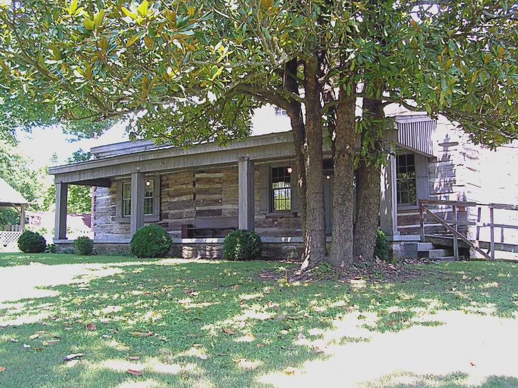
The old house, located on the western slope of Todd’s Knob, was built in 1880 by Alex and Anna Perry. Perry’s house and large farm, called Nutwood, was across McGavock Lane from Spence McGavock’s Two Rivers farm1. Alex Perry died in 1927, and Roberts purchased 150 acres from Perry’s heirs on July 8, 19272. This was only a portion of the Perry tract.

There were eight Perry children, several of whom owned tracts of land carved from their parents’ property. Roberts continued to purchase property from these heirs from time to time. A granddaughter of Governor Roberts has written that his farm eventually comprised 600 acres, including all of Todd’s Knob, and was bounded by Stone’s River3.

Gov. Albert H. Roberts

Roberts had returned to his law practice in Nashville when his two-year term as governor expired in 1921. By 1927 he was 59 years old and probably thinking of retiring when he purchased his farm. It is also possible that he was anxious to have sufficient property for his adult children to be able to live near him. During the 1930s three of his four children owned houses on the farm.

Maurice M. and Hattie Smith Roberts built Stone Cottage, an English cottage-style house, at 3214 McGavock Lane. Sadie Roberts Capps and her husband Paul bought the shingle cottage at 3238 McGavock Lane from Boyd Perry4. Nan Isbell and A. H. Roberts, Jr. built a stone house near the summit of Todd’s Knob. This house was named Fort Houston in honor of Gov. Roberts’ ancestor, Sam Houston. It was designed by McKissack Brothers, Architects5. Helen Roberts, who married Dr. Horace Gayden, lived in Nashville on the southeast corner of Hillsboro Road and Woodmont Boulevard.

After living in Donelson for only four years, Governor Roberts’ first wife, Nora Deane Bowden Roberts, died in 1932. On October 3, 1934, Roberts married Irene Arnstein, who had previously resided on Lauderdale Road in Cherokee Park where she owned a home dry-cleaning machine. On March 7, 1935, as Irene was dry cleaning some clothes in her former home, the machine exploded. Gravely injured, she died the following day at St. Thomas Hospital6. Governor Roberts married a third time, to Mary Edwards, but this union ended in divorce in 1944.

Gov. Roberts died in 1946 and was buried in Livingston, Tennessee7. After his death his children sold the Victorian house and the property to Criswell, Freeman, and Nokes, who developed the Lincoya subdivision on the farmland.

According to Gov. Roberts’ granddaughter, Betty Capps Uffelman, who remained in the Donelson area, there was another house built on the Roberts farm at 3210 McGavock Lane. This was the residence of Maj. Claude Daughtry and his family. Maj. Daughtry was a good friend of A. H. Roberts and had been on his staff when he was governor. This house, on the site of the Donelson Free Will Baptist Church, was razed in the 1990s. (2000)


1 Smith, Elizabeth M. “A Nashvillian Tells Her Story.” Unpublished manuscript. Nashville Room, Ben West Public Library.
2Davidson County Deed Book No. 777, p. 213.
3 The Nashville Tennessean, September 6, 1972.
4 Author’s interview with Mrs. Betty Capps Uffelman, April 3, 2000.
5Aiken, Leona T. Donelson, Tennessee: Its History and Landmarks, pp. 222-224.
6 The Nashville Tennessean, March 7, 1935.
7 Braden, Kenneth S. “The Wizard of Overton: Governor A. H. Roberts of Tennessee.” Unpublished thesis at University of Memphis (also at TSLA), 1983.

Ghostly Tracks of the Tennessee & Pacific Railroad

by Guy Alan Bockmon.

According to Elmer G. Sulzer’s fascinating book, Ghost Railroads of Tennessee, the grandiosely titled Tennessee and Pacific Railroad Company was chartered in 1867. It was to connect Knoxville and Jackson, Mississippi, via Nashville and Memphis.

By 1877 the T&P was serving Nashville, Mt. Olivet, Mud Tavern, Donelson, Hermitage, Green Hill, Mt. Juliet, Silver Springs, Leeville (Stringtown), Tucker’s Gap, and Lebanon. By 1888 the system had become a branch of the NC&StL.

Jere Baxter attempted to acquire the right-of-way for his Tennessee Central line. Frustrated by refusals to sell, he built new tracks nearly paralleling those of the NC&StL. Excursion trains operated by the Tennessee Central Museum still use the TC tracks. The last train ran on the T&P tracks in 1935.

South and west of Elm Hill Pike at Mill Creek I found few remains of the T&P; but visible from both Elm Hill Pike and Massman Drive an abandoned railroad bridge is burdened with junked rail cars*. Eastward from there the former roadbed is marked by rows of power lines marching through the industrial area and across Acorn, Wanda and Sanborn Drives, and then across Briley Parkway.

Photo from NHN collection.

On the south side of Elm Hill Pike east of Ermac Drive, stone support walls of the railroad bridge which once crossed Sims Branch still exist. The right-of-way reappears on the west side of McGavock Pike north of Elm Hill Pike. The two-mile grade from Mud Tavern to Donelson Pike climbed about 100 feet. The N.E.S. poles are visible from Lakeland Drive a few yards above the Gateway Missionary Baptist Church and, farther east, from Seneca Drive.

West of the intersection of McCampbell Road and Donelson Pike, a driveway occupies the roadbed. Nearby Donelson Station changed the name of the former McWhirtersville.

Eastward from Donelson Pike, McCampbell Road runs on the right of and parallel with the procession of power poles. Before crossing Stewart’s Ferry Pike, the pair of roadbeds begin a parallel course.

The power lines terminate at the Nashville Electric Service substation on Stewart’s Ferry Pike. TSLA’s “Davidson County, ca. 1920, Map #1009” shows that the two roadbeds diverged between Stone’s River and Central Pike. The T&P roadbed then became Chandler Road from Central Pike east. At Old Lebanon Dirt Road, the Tennessee Central track and the T&P roadbed resume their side-by-side positions.

After crossing Tulip Grove Road, Chandler Road becomes West Division and then, beyond Mt. Juliet, East Division. The twin roadbeds continue into Rutland, where the tracks veer to the north. At Highway 109, the road doglegs right and left. Renamed Leeville Pike, it continues into Lebanon.


Update from NHN reader Al Grayson (11/2/2013): The cars and the bridge deck are gone by now . . .. This bridge was brought in when the Massman Drive industrial park was developed. It slopes upwards to the east as the western end of the grade was much higher. The old two-lane Elm Hill Pike passed under the approach bridge, whereas the new railroad line crossed Elm Hill at grade. All that is left of the T&P that still has track is an industrial spur off the main railroad track, which was there when the Massman Drive line was reopened in the late 1960s or early ‘70s. It ends just east of Poplar St. and is visible in some of the satellite views [such as Bing and Google maps].

A History of the Buchanan Log House

Adapted by Kathy B. Lauder from the historical research of Nancy Helt and Josef Wilson, founding members of the Donelson-Hermitage Chapter of APTA, and Lu Whitworth, Buchanan-Whitworth researcher.

Members of the Buchanan family have been part of Nashville history from the beginning. Alexander Buchanan died in 1781 in the “Battle of the Bluff,” protecting Fort Nashborough from an Indian attack. Major John Buchanan was living in Buchanan’s Station by 1784. Archibald Buchanan moved his family to the area from Augusta County, Virginia, in 1785 to take charge of a 640-acre land grant called Clover Bottom.  When Archibald died in 1806, his son James, who had spent his early years farming this land, inherited half the property (his uncle Robert Buchanan received the remainder), and purchased 310 additional acres from Thomas Gillespie’s original land grant “on Stone’s River.” This second property, which was not adjacent to Archibald’s grant, included the McCrory’s Creek area where James built what we now know as the Buchanan Log House. Eventually James Buchanan sold his share of Archibald’s property to John Hoggatt, who purchased the other half from Robert Buchanan’s heirs.

James was 46 years old when he finished the three-room log structure in 1809, about 50 years before the Two Rivers and Clover Bottom mansions were completed. A year after completing the house, James married 17-year-old Lucinda “Lucy” East and moved his young bride into the house, where the first of their sixteen children was born in 1811. Their home was one of the earliest log structures built in Middle Tennessee and is one of the few examples of two-story log construction still on its original foundation.

The original building exhibits construction techniques typical of frontier houses. Resting on solid unmortared limestone, the half-dovetail notched logs are chestnut, oak, and yellow poplar. The two-story single-pen original structure measures 18 by 26 feet, with exterior limestone gable-end chimneys flanked by double-hung sash windows. The two-room first floor has a 10-foot ceiling with exposed beaded poplar floor joists. A “ladder” stairway led to the upstairs room, which features a fireplace with an unusual arched limestone lintel marked by an incised keystone.

Buchanan Log House, Donelson, Tennessee (NHN Photo Collection)

By 1820, after ten years of marriage, James and Lucy already had eight children. Needing more space, they constructed a one-and-a-half-story addition measuring 16 by 18 feet. This addition, with an exterior gable and a limestone chimney, created what is known as a saddlebag-type house. Even with the new section, the floor space still totaled only about 1430 square feet, into which they crowded eight more little Buchanans over the next few years. All sixteen children lived to adulthood, and many remained in the Donelson-Hermitage area, where a number of their descendants live today.

Because of the Buchanans’ land holdings and the number of slaves they held – about 15 – the family would have been considered quite wealthy for the period, falling into the upper 10% of the population.

When James Buchanan died at the age of 78 in 1841, he became the first person to be buried in the Buchanan Cemetery* across the road from the house. His tombstone carries this inscription:

Farewell my friends, as you pass by
As you are now, so once was I
As I am now, so you must be
Prepare to die and follow me.

With the help of Addison, her fourth child, Lucy kept the farm going for another 24 years after her husband’s death. She died in 1865, at the age of 73, and was buried near her husband. Her epitaph echoes his:

As thou hast said, I follow you
As all the rest must shortly do
Then be not guilty of any crime
So you may live in heaven sublime.

Her faithful son Addison received a 50-acre plot 1/4 mile east of the family home, where he built a two-room log house (one room downstairs, and one room up). This building has been moved to the 2910 Elm Hill Pike location, just behind the main log house. The move required “chopping” the roof so it could pass under the power lines, and taking the chimney apart, stone by stone, to be rebuilt at the new location. Renovating the Addison Buchanan house included removing the siding to expose the cedar logs and to repair or replace the chinking.

Soon after Lucy’s death, just as the Civil War ended, the property (except for the one-and-a-half-acre Buchanan cemetery) was purchased by Thomas Neal Frazier, a criminal court judge for Rutherford and Davidson counties. Frazier, a Union sympathizer, was impeached by the Tennessee General Assembly in 1866 for a conflict involving the 14th Amendment, but the impeachment was overturned in 1869. Judge Frazier’s son, James B. Frazier, who was a 10-year-old boy when the family moved into the log house, was elected governor of Tennessee in 1903. His administration is remembered primarily for advances in public education. He resigned as governor in 1905 to complete the term of U.S. Senator William B. Bate, who had died in office. Frazier was elected to three more terms in the Senate but lost to Luke Lea in 1911 and returned to his law practice in Chattanooga. Governor Frazier’s mother, Margaret  McReynolds Frazier, lived on in the Log House until her death in 1910. Living with her were her daughter Sarah, with her husband John Harris, and Sarah’s brother Samuel J. Frazier, with his wife Fannie (Whitworth) and their son Neal, who later became a professor and dean at MTSU. Sarah, John, and Samuel, who lived on in the house for close to twenty years after Margaret’s death, all eventually died there. Neighbors referred to the house for years thereafter as the “Frazier place.”

Since 1927 the names on the mail box at 2910 Elm Hill Pike have included Payne, Richardson, Stark, Hudson, Keathly, Williams, and Greer, each of whom made a few changes and additions to the house. In May 1992 the property was purchased by the Metropolitan Nashville Airport Authority, who soon transferred it to the Association for the Preservation of Tennessee Antiquities (APTA), a statewide organization dedicated to the restoration and care of historic sites. Located seven miles from downtown Nashville, the Buchanan Log House is now managed by volunteers from the Donelson-Hermitage Chapter of APTA. Three of James Buchanan’s children married Whitworth siblings, and their descendants care for the Buchanan cemetery to this day.


*Note: this is not the same as the Buchanan’s Station Cemetery.